The Canadian Rockies are home to Canada’s prime mountain wilderness, so it’s not surprising that this mountain range attracts hikers from all around the world.
I was lucky enough to live next to Banff National Park for about three years. During this time, I explored many of the best and most scenic hikes in the area. That being said, you could spend a lifetime here and never run out of trails to hike!
The Canadian Rockies are home to multiple national parks – Yoho, Banff, Jasper and Kootenay. On top of that, the Icefields Parkway drive between Banff and Jasper is one of the most scenic routes in Canada, full of incredible hiking opportunities.
Picture snowy peaks, turquoise blue lakes, hot springs, luxury cabins, glittering glaciers, wildlife, and lush evergreen forests.
In this post, I share my favorite hikes in the Canadian Rockies. Whether you’re looking for a short, family-friendly stroll or a multi-day hiking adventure, I have something for you on this list.
1. Lake O’Hara Alpine Circuit
Trail Basics
- Location: Yoho National Park
- Distance: 10.6km (6.5miles)
- Type: Loop
- Elevation Gain: 886m (2,906 ft)
- Time: 4-6 hours
- Difficulty: Moderate
- Trailhead: Catch the bus from Lake O’Hara parking lot that brings you to Le Relais shelter
Just the word O’Hara brings “oohs” from past hikers who trekked this lake. And it makes sense. You feel a sense of awe when you’re looking at the sparkling emerald blue waters of Lake O’Hara straight from the top of the Alpine Circuit hike. This may be one of the best (if not the best) day hikes in the Canadian Rockies. The route is simply divine!
Lake O’Hara is in Yoho National Park. It’s a dream hiking destination dotted with meadows, lookouts, ridge walks, turquoise lakes, and meticulously shaped stone trails.
What makes this hike even more special is that a quota system limits the number of hikers. You are not allowed to drive your own car to the trailhead. Instead Lake O’Hara reservations must be booked months in advance to take the bus to Lake O’Hara for day use and camping from mid-June to early October.
Reservations open from April for the summer season, but check the website for the exact date as the reservations fill up quickly. Cancellations do happen (this is how Kristen snagged a permit!), so don’t lose hope if you don’t manage to get your spot.
After the 20-minute bus trip to the lake, you’ll get dropped off at Le Relais, a wooden shelter where books and maps are sold. I recommend going clockwise, tackling the steep ascent to Wiwaxy Gap when your legs are fresh. Along your route, you’ll pass the stunning Lake Oesa and Opabin Lake. You’ll also have sweeping views of some of the most iconic peaks in the Canadian Rockies.
If you want to extend your hike beyond a day trip, you can spend a few days either in the historic Elizabeth Parker alpine hut or in the Lake O’Hara campground. Since the hut sleeps 20 people, it’s a great way to meet new like-minded folks.
Read Kristen’s experience about camping at Lake O’Hara for a full three-day itinerary.
Shuttle Reservations
Reservations are only required for the inbound shuttle, outgoing buses fill on demand.
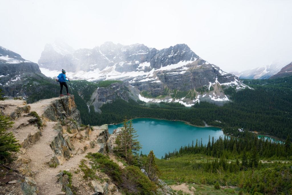
Kristen enjoying the views from the lookout over O’Hara Lake on the Wiwaxy Gap section of the hike
2. Johnston Canyon
Trail Basics
- Location: Banff National Park
- Distance: 5.3 km (3.3 miles) roundtrip to Upper Falls
- Type: Out-and-back
- Elevation Gain: 270m (885 ft)
- Time: 1.5 – 2 hours
- Difficulty: Easy to moderate (family-friendly)
- Trailhead: Off Hwy 1A at Johnston Canyon parking lot
Johnston Canyon is possibly one the most popular hikes in the Canadian Rockies, but rightly so. The canyon is beautiful all year round, but I find it especially enchanting in winter when the waterfalls freeze. The frozen canyon walls at Johnston Canyon become a winter wonderland that you can ice climb.
A short and easy 1.1 km (0.7 mile) trail takes you up catwalks through a towering canyon to the 10-meter (33-foot) Lower Falls. If you keep walking, you’ll reach 30-meter (100-foot) Upper Falls. Passing through the tunnel was one of the highlights for me!
It’s worth hiking up to Upper Falls to pass through the rock tunnel | Photo credit: Kamila Jakubjakova
Continue past the crowds and venture 5 km (3.1 miles) further to the Ink Pots – six green natural pools, which will take you closer to four hours roundtrip. It’s a magical place and much quieter after the tourist rush of the canyon.
There is also nearby Johnston Canyon Campground. It’s a tranquil campground nestled in a pleasant forest less than 20 minutes from Banff. The scenery is spectacular, and the wildlife is abundant in and around this campground. A small creek flows right by the camping area.
After your hike, you can spend the rest of the day exploring Banff and eating at one of the many top-notch restaurants. While here, you shouldn’t miss out on taking a dip at Banff Upper Hot Springs.
If you plan to visit Johnston Canyon in winter, spending white Christmas in Banff combined with world-class skiing is especially magical.
Hiking Johnston Canyon in the Winter
Winter is a magical time to hike Johnston Canyon, but I recommend wearing microspikes if you do. The path can be icy and slippery. Microspikes add extra traction and reduce the risk of slipping or falling.
3. Skyline Trail
Trail Basics
- Location: Jasper National Park
- Distance: 44km (27.3 miles) one way
- Type: One-way
- Elevation Gain: 1,560m (5,118 feet)
- Time: 2-3 day trek
- Difficulty: Moderate to hard
- Trailhead: Maligne Lake
One of the best multi-day hikes in the Canadian Rockies is Skyline Trail, which winds for about 44 km (27 miles) past some of the Jasper National Park’s most striking scenery.
The trail has the highest elevation gain in the park, and the weather can be super unpredictable here, so I recommend packing extra layers. Unfortunately, this isn’t one of those hikes that you can do as a spontaneous weekend getaway. It requires a fair bit of planning.
Firstly, you have to book the backcountry permit months in advance to hike the Skyline trail. On the plus side, it also means the hiking trail doesn’t get too overcrowded.
Parks Canada limits the number of people it allows into these areas to protect the fragile terrain. All the reservations typically get snatched up within a few hours on the day that reservations open, so keep an eye on the website.
It’s a multi-day hike (2 or 3 days) with overnight stops at campsites* or the rustic Shovel Pass Lodge, which is halfway along the Skyline trail. The lodge was built in 1921, and I love its super cozy rustic vibe. Delicious home-cooked dinners and breakfasts plus lunch bags are included in the price. All the supplies and food ingredients are delivered to the Shovel Pass Lodge by horses twice a week to make this experience possible. How awesome is that!
Reservations for Shovel Pass Lodge open in November for the following year.
View of the Watchtower Mountain from the Skyline Trail near Jasper, Alberta
Tips for hiking Skyline Trail
- You can park at the North Skyline / Signal Mountain Trailhead (the end of Skyline Trail), from where you can take a shuttle bus to Maligne Lake (the start of the trail).
- *Available campsites along Skyline Trail are Evelyn Creek, Little Shovel, Snowbowl, Curator, Tekarra & Signal.
4. Sulphur Skyline Trail
Trail Basics
- Location: Jasper National Park
- Distance: 8km (5 miles)
- Type: Out-and-back
- Elevation Gain: 700 meters (2,297 feet)
- Time: 4-6 hours roundtrip
- Difficulty: Moderate
- Trailhead: Miette Hot Springs parking area
Not to be mistaken with Skyline Trail that I mentioned above, the 8km (5-mile) Sulphur Skyline Trail is another wonderful scenic Canadian Rockies hike in Jasper.
From the summit, you can see the Fiddle River Valley, the Miette Mountain Range, and the cliffs of Asher Ridge.
This trail is particularly lovely in the autumn when all the colorful leaves pop up. However, I might be biased because I absolutely adore Canadian autumn!
Sulphur is a fairly challenging hike, with 700 m (2,297 feet) of elevation gain. The first 2 km (1.4 miles) is a steady climb and the trail becomes very rocky and steep near the top.
My favorite part of this hike, though is soaking at Miette Hot Springs after you return back down the trail. The warm water feels super rewarding and relaxing. These are paid hot springs, but the entrance fee is worth it for a few hours of bliss.
Oh, and did I mention they’re the hottest hot springs in the Canadian Rockies? The hot springs’ natural temperature is 54°C (129°F) but the pool is cooled down to a comfortable 40°C (104°F).
Also, keep your eyes peeled for bighorn sheep on the road that leads to Miette Hot Springs.
Tips for hiking Skyline Sulphur Trail
- Miette Road leading to the trailhead is closed from mid-October to mid-May. The hot springs are also closed from October to May as well.
- Hiking poles can come in handy when going up and coming down the steep sections.
5. Floe Lake
Trail Basics
- Location: Kootenay National Park
- Distance: 21 km (12.6 miles)
- Type: Out-and-back
- Elevation Gain: 800m (2,624 ft)
- Time: 3 – 5 hours each way
- Difficulty: Hard
- Trailhead: Floe Lake parking lot, just off Highway 93
Floe Lake is one of the highlights this hike, but the entire trail has stunning views. Before putting it on you hike-it list, though, it’s important to know that the hike to Floe Lake isn’t easy. It requires about 20km (12.6 miles) of walking, but it sure is worth the effort and sweat!
Once you get to the lake, you can reward yourself with a dip in the water to cool down if it’s a hot summer day. At the top, you’ll also find Floe Lake Warden Patrol Cabin in its spectacular setting close to the shores of Floe Lake.
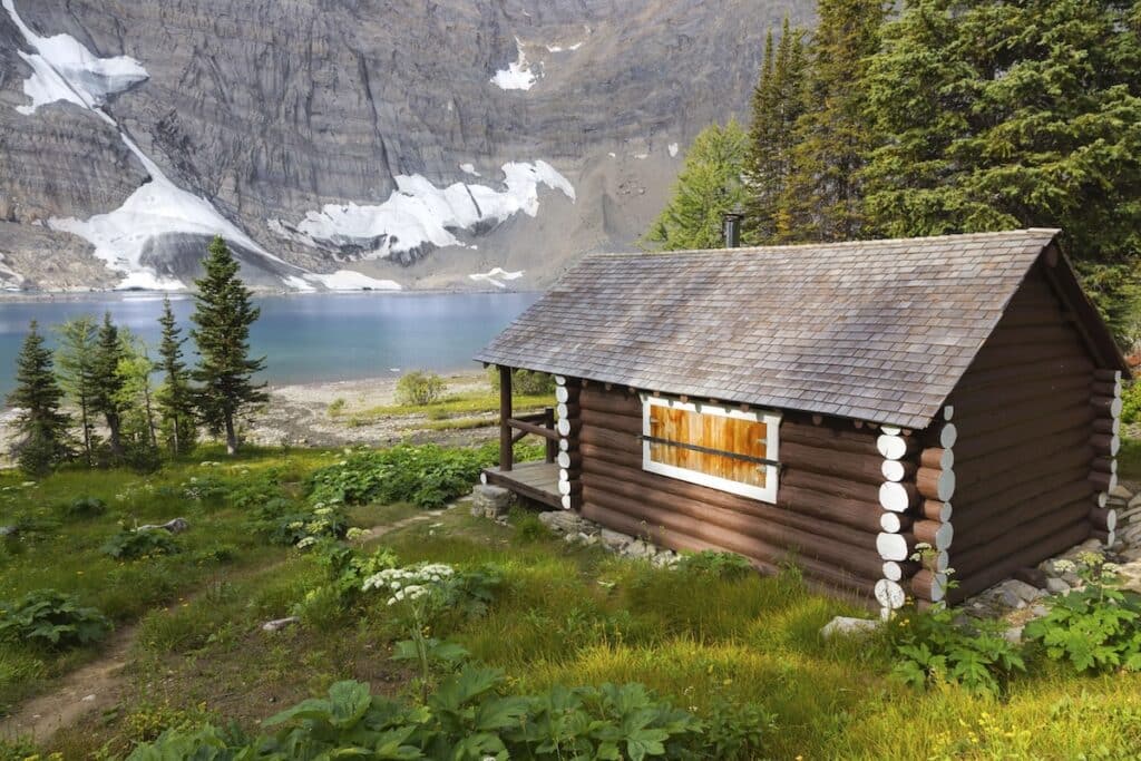
The Floe Lake Warden Patrol Cabin is set in a stunning location on the shores of Floe Lake
The hike is manageable within a day, but I suggest staying overnight at Floe Lake Campground if you have two days. The lake is the most photogenic in the morning, too, so spending the night will allow you enjoy the early morning views. Keep in mind that the Floe Lake Campground is the most popular backcountry campground in Kootenay National Park, so book as soon as the reservations open each year.
If you can’t get enough of the Canadian Rocky Mountains’ natural beauty, you can also make it into a multi-day trip along The Rockwall Trail.
Tip: The trail to Floe Lake leads largely through a burn area with little to no shade, which means full sun exposure on a hot day. Bring lots of water, sun protection, and sunblock. (A massive fire ravaged this area in 2003).
6. Tent Ridge
Trail Basics
- Location: Kananaskis
- Distance: 10.1 km (6.3 miles)
- Type: Loop
- Elevation Gain: 810m (2,657 ft)
- Time: 3-6 hours
- Difficulty: Moderate to Hard
- Trailhead: Mt Shark Road (not far past the Mount Engadine Lodge)
Tent Ridge is my absolute favorite hike in Kananaskis. At the top, you get 360 jaw-dropping views over Spray Valley, the reservoir and the highest peaks in Kananaskis Country.
But be prepared to work for it! There are a few technical portions where you have to scramble and climb rocks, which can be a bit nerve-wracking and intimidating for newer hikers. Hiking poles are really helpful to have along this sections. I recommend doing the hike clockwise because counterclockwise direction is way more challenging. If you can, go for a sunrise. You won’t regret it!
Another thing to keep in mind is that the road leading to the trailhead isn’t paved, so get ready for a 40-minute drive on a gravel road with many potholes. Also, there are no outhouses along the trail, but there is one at Spray Lake, which you’ll pass 5-10 minutes before getting to the trailhead.
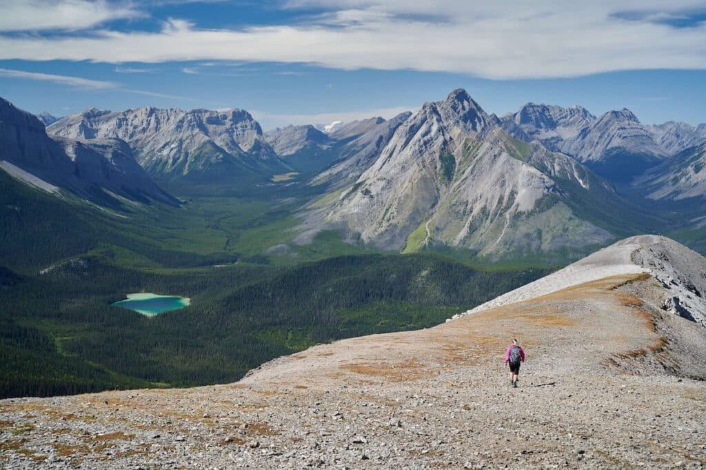
The views from Tent Ridge trail are some of the best in the Canadian Rockies
7. Lake Agnes Trail
Trail Basics
- Location: Banff National Park
- Distance: 7.4km (4.6 miles)
- Type: Out-and-back
- Elevation Gain: 384m (1,259 ft)
- Time: 2.5 hours roundtrip
- Difficulty: Moderate (family-friendly)
- Trailhead: Fairmont Chateau in Lake Louise
There are dozens of popular day hikes in Banff National Park to choose from, but Lake Agnes deserves the spot on this list of the best hikes in the Canadian Rockies. In autumn, the yellows of the larch season are especially beautiful.
Fairmont Chateau Lake Louise Hotel is a starting point for several short, moderately strenuous Canadian Rockies hiking trails, including this 7.4 km (4.6-mile) return hike to Lake Agnes or, as some like to call it, “The Lake in the Clouds”.
The trail passes through an old-growth forest and a waterfall before ending at Lake Agnes teahouse, where you can stop for tea and dessert (bring cash). The teahouse also serves soups, sandwiches, and snacks. I love, that you can enjoy tea on top of a mountain with glorious lake views. I mean, what’s there not to love about sipping tea and appreciating the wonderful view?
For more incredible mountain views, keep walking down the trail towards Beehives. From the Lake Agnes Tea House, you’ll follow the well-signed trail as it heads back down to Lake Louise, passing Mirror Lake along the way.
Tip: In 2021, Parks Canada implemented a mandatory parking fee for the Lake Louise parking lot from mid-May to mid-October. Alternately you can take a shuttle. Learn more about Lake Louise parking and shuttle.

If you keep walking past Lake Agnes towards Beehives, you’ll get incredible views down onto Lake Louise | Photo credit: Kamila Jakubjakova
8. Emerald Lake Loop
Trail Basics
- Location: Yoho National Park
- Distance: 4.1km (2.5 miles)
- Type: Loop
- Elevation Gain: 44m (144 ft)
- Time: 1 hour
- Difficulty: Easy (family-friendly)
- Trailhead: Emerald Lake parking area
On my first visit to Emerald Lake, I remember thinking to myself, I understand how it got its name. Emerald-green water surrounded by towering mountains makes this lake nothing short of extraordinary. It’s easily one of the most photogenic destinations in all of Canada.
The 5km (3 miles) loop around the lake is mostly flat and easy to hike. The best views are from the western shoreline. If you feel adventurous, you can extend your walk and climb towards Emerald Basin. Alternatively, you can escape the crowds by renting a canoe and paddling across the lake.
When you’re done with your hike or paddle, grab a coffee, ice cream, a house-baked cookie, or a light lunch at Emerald Lake Lodge, which has an outdoor patio restaurant overlooking the lake.
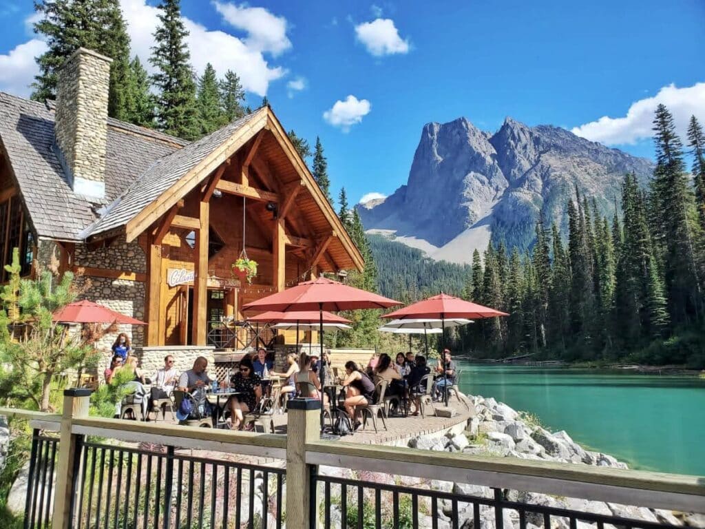
After your hike, sit on the patio outside the Emerald Lake Lodge to take in the views and emerald green water | Photo credit: Kamila Jakubjakova
You can also explore the area further by taking the short trail (800 meters (0.5 miles) to Hamilton Falls. The trail continues to Hamilton Lake which is quieter and way less crowded than Emerald Lake. It’s a steep hike so a good cardio workout.
Tip: Don’t miss the chance to see Canada’s highest waterfall at 373 meters – Takakkaw Falls, which is only half an hour’s drive from Emerald Lake. The falls are easily accessible from the parking lot.
Other Amazing Hikes in the Canadian Rockies
Looking for more hikes? Here are a few more to add to your list:
- Iceline Trail (Yoho National Park, 21.7 km loop)
- Laughing Falls Trail (Yoho National Park, 8.7 km round trip)
- Berg Lake Trail (Mount Robson Provincial Park, 41.5 km round trip)
- Wilcox Pass Trail (Jasper National Park, 9.5 km round trip)
- Parker Ridge (Banff National Park, 5-6.5 km round trip)
- Sentinel Pass (Banff National Park, 11.6 km round trip)
- Smutwood Peak (Kananaskis, 17.9 km round trip)
- Galatea Lakes (Spray Valley Provincial Park, 16.4 km round trip)
- Fairview Mountain Trail (Lake Louise, 7.4 km round trip)
- Bald Hills Trail (Jasper National Park, 14 km round trip)
- Assiniboine Lodge to Nub Peak (Mt. Assiniboine Provincial Park, 9.2 km round trip)
- Grassi Lakes (Canmore, 3.4 km loop)
- Pocaterra Ridge (Kananaskis, 9.3 km round trip)
- Larch Tree Valley (Banff National Park, 8.6 km round trip)
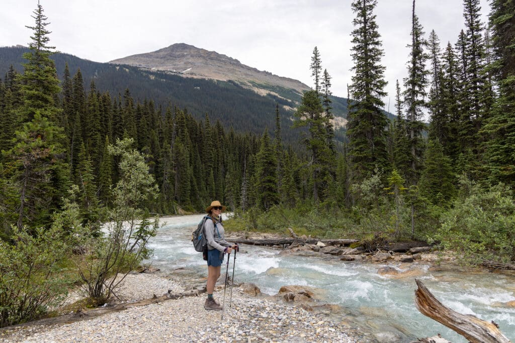
Kristin on Laughing Falls trail during her Icefields Parkway road trip
Wildlife Safety in the Canadian Rockies
Hiking in the Canadian Rockies is not only about the stunning scenery but also unforgettable wildlife viewing opportunities. From herds of elk and moose to black bears and mountain goats, you name it.
Here are a few tips about staying safe and respecting wildlife in the Canadian Rockies:
- If you’re driving and you see wildlife on or near the road, stay in your vehicle with the windows up. Don’t stop on the road unless there’s a safe place to pull over.
- Bears are generally pretty harmless and prefer to avoid people. However, it’s recommended that you carry bear spray in case you come across a territorial grizzly bear.
- When hiking, according to the Government of Canada website, it’s advisable to make loud noises – clap, sing, and talk loudly. This will make bears aware of your presence and give them time to move away from you.
- Be careful when taking pictures of wild animals, as they may feel threatened, especially mama bears. They may try to attack you to protect their cubs.
- If you are traveling with pets, keep them leashed at all times.
- Stay on the trails and don’t try to get close to the wildlife. After all, these majestic creatures are wild and unpredictable. Enjoy viewing them from a safe distance.
Useful Tips for Hiking in the Canadian Rockies
New to hiking in the Canadian Rockies? Here are a few tips to help you plan your trip and stay safe on the trails:
- Before heading out on a hike in the Canadian Rockies, check the trail reports on the Parks Canada website for trail conditions, closures, restrictions, and what hiking gear is recommended for each specific trail.
- If you plan to hike in the backcountry, it pays off to invest in detailed maps and a compass. Visitor’s centers will have local maps or you can download them online on Gem Trek or AllTrails.
- Generally, pets are allowed in Canadian national parks, including campgrounds, but they need to be kept on a leash.
- The weather is highly unpredictable in the Canadian Rockies. That’s why it’s a good idea to carry extra layers when you’re out and about, especially if you’re hiking. You’ll also want to pack water and snacks.
- Useful apps for traveling in the Canadian Rockies include WikiCamps Canada and iOverlander – both have a database of campgrounds, RV parks, points of interest, dump stations, visitor information centers, water taps, toilets, showers, and more.
- Parks Canada, the Canadian equivalent of the United States NPS, issues an annual Discovery Pass that allows free entry to 80 parks and other sites.
- Wildfires have become a big concern, especially in recent years, so most summers, there is a fire ban in Alberta and British Columbia. But cooking on propane camp stoves is fine.
Planning a Canadian Rockies road trip? Check out these posts to help plan your adventure:
Save this post to Pinterest
Have you hiked in the Canadian Rockies? What are your favorite treks? Which ones are on your bucket list? Leave a comment below!
The post 8 Best Hikes in the Canadian Rockies (+ Local Tips!) appeared first on Bearfoot Theory.
https://bearfoottheory.com/canadian-rockies-best-hikes/
 CampingSurvivalistHuntingFishingExploringHikingPrivacy PolicyTerms And Conditions