× CampingSurvivalistHuntingFishingExploringHikingPrivacy PolicyTerms And Conditions
Subscribe To Our Newsletter

Ride Report: Bikepacking the Anza-Hapaha Loop in Southern California

Spring is here, and what better time to go play in the desert? During this fleeting window between winter’s chill and summer’s scorching heat I recently enjoyed a 4-day bikepacking trip with friends in beautiful Anza Borrego Desert State Park. 

This massive state park, the largest in California, lies east of San Diego between the Laguna Mountains and Salton Sea. It offers sandy canyons, rugged hills, scrubby cactus and delicate wildflowers, and glimpses into a long indigenous history.

We chose to explore the Anza Borrego Desert via the 90 mile Anza-Hapaha Loop from bikepacking.com. There are other routes in the area (like this and this) that make heavy use of the S2 highway, but we wanted to spend as much time as possible off pavement. The Anza-Hapaha Loop travels up two long canyons on dirt and sand roads, climbs over steep hills with vast views on rugged jeep tracks, and includes just barely enough water refill options to be feasible at a relaxed pace. 

This short loop makes a great long weekend desert bikepacking trip, and if you’re in the southern California area I definitely recommend it. Here’s a ride report with logistics info, daily notes, and pictures to inspire you.


Ride Report: Bikepacking the Anza-Hapaha Loop in Southern California

Route Overview

The Anza-Hapaha Loop is part of bikepacking.com’s Local Overnighter route network. Here’s their RideWithGPS map:

When to ride: any time except summer (too hot)

  • March and early April are ideal for catching the spring wildflower bloom, though this also brings more visitors and traffic to the area.
  • October and November can also be nice, but potentially hot in early Oct.
  • Winter can work, but keep an eye on the weather forecast and be prepared for cold nights and short daylight hours.

Highlights:

  • Catching the spring wildflower bloom if timing is right
  • Mostly low-traffic dirt and sand roads
  • Free and legal dispersed camping
  • Classic desert vibes

Challenges:

  • Limited water availability
  • Some sandy sections
  • Some short steep hike-a-bikes
  • Potential for strong wind
  • Short sections of potentially busy highway

Which Direction to Ride?

The route is mapped clockwise, that’s the way we rode it, and we’re glad we did! A number of commenters on bikepacking.com have ridden counterclockwise and liked it, which surprised me, so I want to elaborate on the pros and cons of each.

Traffic: If you don’t like spending time on shoulderless highways with potentially heavy RV and toy hauler traffic, you should ride clockwise, especially during weekends and popular tourist times. This direction makes all the significant road sections (4 miles on Highway 78, and the 8 mile drop into Borrego Springs on Montezuma Valley Road) fast and easy descents.

Note that traffic patterns in this area are largely recreational. The four miles to Grapevine Canyon on Highway 78, which we coasted down on Sunday afternoon, would have been unrideable for me as a climb due to all the weekend recreation traffic heading west and uphill. Presumably the opposite pattern prevails on Friday afternoon and Saturday morning, but at least it’s over quickly if you’re riding clockwise.

Sand and climbing: Folks who ride counterclockwise generally cite Fish Creek Wash as the reason. Going clockwise it’s about 9 miles of gradual climbing with potentially challenging sand (depends on timing and conditions). Going counterclockwise you get to descend it, which helps a bit. In my opinion the grade isn’t steep enough to make a huge difference – if the sand is deep you might be walking regardless of direction – and I’d rather spend time slogging through sand here than grinding uphill on busy shoulderless highways.

Wind: Check the wind forecast before making your final decision. We had a screaming tailwind pushing us east on day 1, and trying to ride the opposite direction would have been a major bummer.

Suggested Itineraries

I think a majority of bikepackers will want three days to complete this loop. Here’s a nice way to break up the mileage:

  • Day 1: camp partway up Fish Creek Wash or at Hapaha Flat, at most about 45 miles and 3000 feet of climb
  • Day 2: camp shortly after turning right out of Grapevine Canyon, about 29 miles and 3600 feet of climb from Hapaha Flat
  • Day 3: back to Borrego Springs, about 16 miles and 1400 feet of climb (short day)

Our group consisted of three people with varied paces and loads, so we stretched our ride to four days (with an 11am start on day one and a noon finish on day four) to keep things fun. The main challenge with this pace is water; we had to load up with 8 liters to get us between day 1 afternoon and day 3 midday. This was our itinerary:

  • Day 1: camp at Fish Creek Primitive Campground, about 30 miles and 1100 feet of climb (plus ~5 miles off route to Ocotillo Wells and back for water)
  • Day 2: camp at the dip after Split Boulder and before the top of the first big climb, about 20 miles and 3000 feet of climb
  • Day 3: camp at flatish spot shortly after turning right out of Grapevine Canyon, about 24 miles and 2600 feet of climb
  • Day 4: back to Borrego Springs, about 16 miles and 1400 feet of climb (there by lunchtime)

If you’re feeling motivated and the conditions are in your favor (no blasting headwinds or long stretches of deep sand) this loop is doable in two days. That might look something like this:

  • Day 1: camp at Split Boulder or in the dip just after, before the top of the first big climb, about 50 miles and 4000 feet of climb
  • Day 2: back to Borrego Springs, about 40 miles and 4000 feet of climb

Parking

The route description says to park at the public library or sheriff’s office, but I don’t recommend either. The library’s security guard told us we couldn’t park there overnight, and the sheriff’s parking lot has signs saying no overnight parking (and no one was around to ask for permission).

Instead, we parked on Sunset Road alongside the community garden and Art Park. We ran it by a local first, but I believe it should be fine regardless. It’s a public street with plenty of space and what looks like a few long-term vans and RVs parked there.

Water and Food Resupply

Water is a major consideration on this route, as there are no reliable natural sources to be found. We rode in early April after a fairly rainy period and still didn’t encounter any, except perhaps a spring in Grapevine Canyon that we didn’t check (we were already carrying plenty). Fortunately there are two RV parks well-spaced along the route where you can fill up on water and top up your food supply.

The first is in Ocotillo Wells, about two miles off-route north of mile 24 on Old Kane Springs road. There’s a small store where you can buy minimal snacks (mostly candy) and a simple meal (ramen, canned food, and the like). The store sells water, and if they’re closed there’s the RV Park next door.

The second refill is the Stagecoach RV Resort on S2. The store is well stocked and has some hot food options including pizza, but is closed Sunday and Monday. A water spigot can be found in front of the store, even when it’s closed, or in the RV park. The RV Park has vending machines selling cold soda and electrolytes.

Each person in our group had a max water capacity of 8 – 9 liters, and we used it all to get between Ocotillo Wells and Stagecoach RV Resort. Our slower four day pace meant two nights of dry camping with a full day between. Fortunately we didn’t have hot daytime temps, as this would have required even more water and probably made this pace impractical.

If you’re not sure how to carry all this water, see my post about carrying water while bikepacking for lots of ideas. On this trip I made it work using a collapsible backpack (3 liters), two bottles (on down tube and in stem bag), and several collapsible containers stuffed in various bike bags.

Camping

Anza Borrego Desert State Park allows dispersed camping in most areas, provided campers follow leave no trace principles. We noticed two short sections of cultural preserve where dispersed camping is not allowed: a couple miles in Grapevine Canyon, and the final section of descent into Culp Valley before the paved descent into Borrego Springs.

We had no trouble finding camping where we needed it, and if you use the usual skills for sniffing out good spots you probably won’t either. Specifically: don’t camp in dry washes when rain is in the forecast(!), look for flat spots on the topo map and avoid areas where the road cuts across a steep hillside, don’t trample delicate foliage, and be wary of exposed spots without wind protection.


Bikepacking bike and small tent in scrubby desert landscape
Dispersed campsite just above Grapevine Canyon on night 3

Important: Fish Creek Wash is subject to flash flooding when it rains nearby, so keep an eye on the weather and don’t camp directly in the wash if there’s any chance of rain. The primitive campground near the bottom is elevated and safe, and you can find other dispersed camping spots on high ground as you travel up the wash.

Terrain and Road Conditions

The majority of this route is on moderate terrain with gradual climbing and smooth descending, but there are a few challenges to be aware of.

Sand: The 9-ish miles of Fish Creek Wash can be sandy, with the severity depending on recent conditions (rain can help pack it down) and traffic (vehicles churn it up). The section along Old Kane Springs Road to Ocotillo Wells can also be a sandy slog in places. Overall I found the sand on this route better than expected and was able to ride enough of it, even with 2.35” tires. That said, I’m a light person and recently bikepacked in Baja where the sand is truly heinous, and we had a tailwind on Old Kane Springs Road, so my perspective may be skewed.


Bikepacking bike lying on sandy desert road in Fish Creek Wash
Some sandy washboard in Fish Creek Wash

Steeps: There are two big climbs on this route and both are fairly gradual up until the last few miles. But those last few miles are doozies! The section leading up to the first high point is an undulating jeep road with some truly impressive steep pitches. The worst one (you’ll know it when you see it) has a motorbike bypass on the outside of the curve, which I highly recommend taking. The downhills in these sections have a few short technical sections that some will want to walk.


Ride Report: Bikepacking the Anza-Hapaha Loop in Southern California
Looking back down the steepest of the hike-a-bikes, which required two people per bike to ascend (or better yet, take the motorbike bypass to the outside of the curve, which we discovered later).

Traffic: The dirt and sand roads have fairly low traffic, but you should still watch out for 4x4s and motorbikes moving quickly through the washes. Fortunately for us bikepackers, Anza Borrego State Park only allows street legal vehicles (no ATVs) which definitely helps. The short sections of paved road can be a bit stressful if traffic is heavy, but they’re over quickly if you ride clockwise. I definitely recommend a rear blinky and bright colors, a rear view mirror, and all the usual traffic safety measures.

Bike and Gear Notes

Bikes: Our group of three rode two hardtail mountain bikes with flat bars and one rigid drop bar Salsa Fargo. All were fine choices. A suspension fork and dropper seatpost aren’t necessary for this route, though they are helpful in a few places. My ideal bike for this route would probably be a fully rigid mountain bike (I tend to only use suspension when I really need it) with flat bars.

Tires: Wider is helpful for the sand. Our group ran 29 x 2.35” and 29 x 2.4”, which were sufficient in most places but a bit on the narrow side. If you’re rolling with a heavier load or really want to minimize walking, consider 2.6” or wider. Tubeless tires highly recommend because of all the spikey desert foliage.

Sleeping pads: This route is in cactus country! Users of inflatable sleeping pads should carry a thin foam underpad and/or check your tent site very carefully before setting up. I managed to avoid punctures without using an underpad, but I came very close on night three. Fortunately a careful sweep of my hands over my tent floor revealed all the pokey bits just in time.

Clothing: Deserts are known for their wide temperature swings, and we certainly experienced this during our April ride. Be prepared for chilly nights, cold wind, and also hot sunny afternoons.


Loaded bikepacking bike leans against juniper shrub
My bike, a Chumba Stella in hardtail mode, against a juniper bush on day 3 of this ride.

Daily Notes

Day 0

We were lucky to snag a last-minute spot at the State Park campground in Borrego Springs, where we had a very windy night! If the campground is full there is free dispersed camping to the northeast of town near the Peg Leg historical marker. The two grocery stores in Borrego Springs are decent, but if you want something specific better to buy it before you get there. 


Solo tent in desert scrub at the Borrego Springs campground, with mountains and storm clouds in background
Wind and ominous clouds at the state park campground in Borrego Springs as we prepare for our ride.

Day 1

35 miles (including 5 miles out and back to Ocotillo Wells), camped at Fish Creek Primitive Campground

We didn’t leave Borrego Springs until 11am, but a screaming tailwind helped us make up for lost time. We didn’t linger long in the amazing sculpture gardens, unfortunately, because the wind was so chilly and insistent on our eastward progress. The straight shot along Old Kane Springs Road looked like it could be a bit of a slog in the wrong wind, but we felt like we had motors as we sped along the rocky, sandy track between various shrubs, cholla cactus, and flowering ocotillo.


Ride Report: Bikepacking the Anza-Hapaha Loop in Southern California

Ride Report: Bikepacking the Anza-Hapaha Loop in Southern California

Ride Report: Bikepacking the Anza-Hapaha Loop in Southern California
Old Kane Springs Road is alternately sandy and rocky, but it passed quickly for us thanks to an amazing tailwind.

At mile 24 we turned north and rode a couple miles off-route to the store and RV park in Ocotillo Wells. While waiting out a very brief rain shower we bought some snacks and water, and chatted with the store owners about the weather forecast.

Fortunately the rain cleared up quickly, though the crosswind continued as we headed south to the start of Fish Creek Wash. Our bikes felt sluggish loaded down with 8 liters of water each, enough to get us through the following day and night. Some of the homes in this area, mainly RVs lined up in grids across the windy desert floor, showed hints of that quirky artistic sense of humor seemingly common in desert communities.


Ride Report: Bikepacking the Anza-Hapaha Loop in Southern California
A mailbox labeled “junk mail” atop a very high pole, presumably a bit of artistic humor in this quirky desert community.

Ride Report: Bikepacking the Anza-Hapaha Loop in Southern California
The start of Fish Creek Wash, shortly before the primitive campground (photo by Denise)

With potential overnight rain in the forecast, we decided to camp on high ground at the primitive campground near the start of Fish Creek Wash. The campground was fairly full but the vibe was pleasant. The wind raged as we tried to pitch our little tents, using all the extra guy lines and piles of rocks to keep them stable.


Three bikepacking tents at a desert campground with canyon walls and several trucks and campers in background.
Our three tents securely anchored with rocks and guy lines to resist the wind at Fish Creek Primitive Campground

Just before falling asleep I heard a smattering of rain on my tent and poked my head out to a perfectly clear and starry sky. I couldn’t see a single cloud! The rain must have been blowing nearly horizontally from clouds out of sight beyond the hills.

The campground costs $20 per night (cash or check, no change available) and is first come first served. There’s a pit toilet but no water. If it’s full or you prefer more solitude there are also nice dispersed sites further up the wash.

Day 2

20 miles and about 3000 feet of climb

The morning dawned clear and calm, a relief after so much wind. Our project for the day would be working our way up Fish Creek Wash, a gradual but sometimes sandy and washboarded climb. At times the walls rose dramatically overhead, elsewhere the canyon was broad and gentle. The sun felt hotter than we expected, though the air was still cool in the shade. There was some vehicle traffic in the wash, but not as much as we’d feared, and it decreased the further we went.


Bikepacker rides beside tall canyon walls in sandy Fish Creek Wash
In some places the walls of Fish Creek Canyon are impressively tall

After leaving the main wash around 9 miles in, the road narrowed and steepened a bit. We made slow and steady progress all the way up to Split Boulder. It’s a nice spot to camp (though right next to the quiet dirt road), and around the back you can see faint pictographs and grinding holes from previous indigenous residents.

We opted to go a bit further, descending to the little dip in the elevation profile at mile 50. Here we found a lovely campsite a bit up the wash on the right, just past where the road turns left and starts climbing more steeply. At this higher elevation the air quickly turned cold and chased us into our tents as darkness fell.


Rocky and sandy desert jeep road with mountain bike handlebar in foreground
Descending the short downhill before the final climb begins. Here the road gets a bit rougher.

Three bikepacking tents at dusk in a sandy desert campsite
Settling into our cozy campsite on night 2

Day 3

25 miles and 2700 feet of climb, to just after the route turns right out of Grapevine Canyon

The night was chilly but we were cozy in our tents, and the sun warmed us quickly in the morning. We set out to finish the last bit of climb and quickly realized the character had shifted. We were now on a rugged jeep road with some truly impressive obstacles, and we marveled at the skill of the drivers we had seen navigating them from afar the evening before! 

This section required some patience and strength for the short steep hike-a-bikes, including one truly epic section where we teamed up with two people per bike. (Hint: look for the motorbike bypass on the steepest rocky climb.) We were finally rewarded by a smooth and fast descent down to Stagecoach RV Resort, our first real descent of the route.
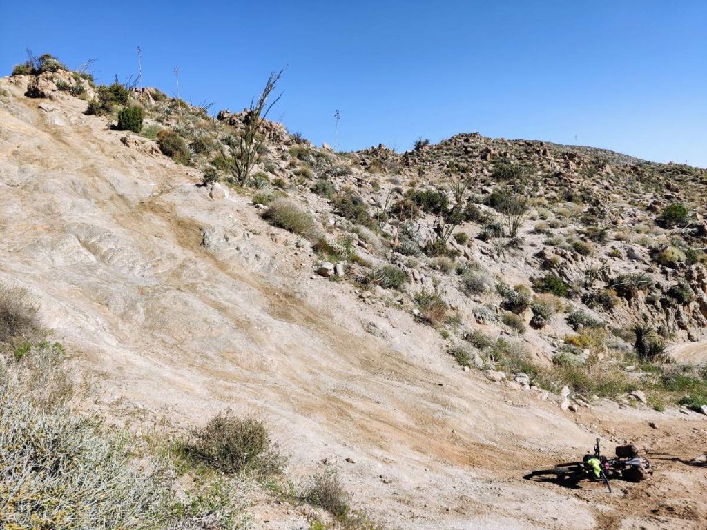

Bicycle lies at bottom of steep rocky hillside in Anza Borrego Desert
Side view of the steepest section of road. Two of us teamed up to get one bike up this monster before deciding the motorbike bypass would be easier.
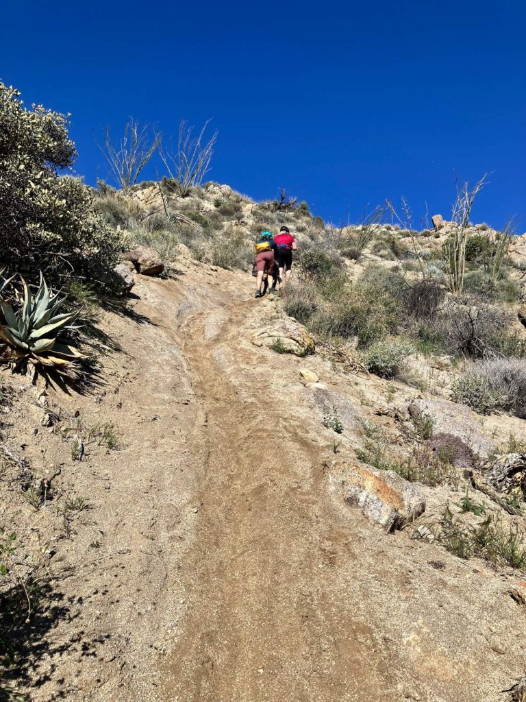
Two women push a loaded bikepacking bike up a steep desert trail
Teaming up to push another bike up the easier, but still steep, motorbike bypass (photo by Genna)
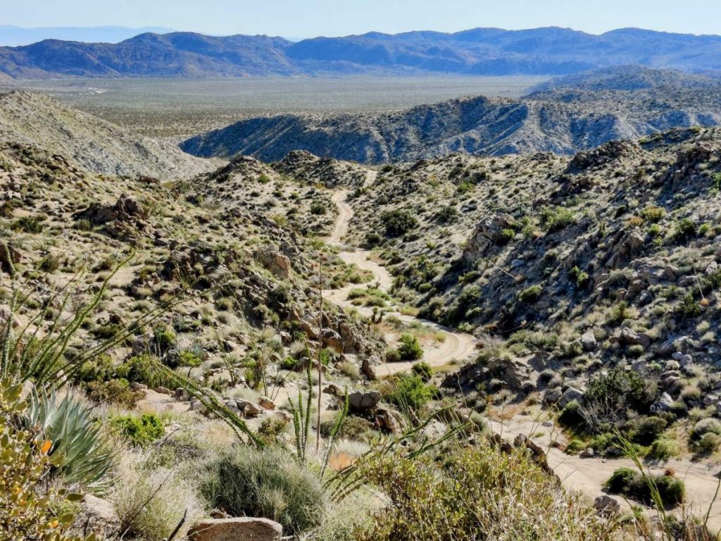
Expansive view of winding dirt road through rugged desert landscape
Hard-earned view from the top of the steep climb

We were disappointed, and somewhat surprised, to realize we hadn’t checked the Stagecoach RV Resort’s hours. They are closed on Sundays and Mondays! We were able to fill water from the spigot out front, buy drinks from the vending machine, and charge our devices at an outlet, but couldn’t enjoy the pizza and ice cream cruelly displayed on the signs out front. After some discussion we decided our collective food supply would be enough to get us through the route successfully, if a bit hungrily, so we rolled out on the pavement toward Highway 78.

The four mile descent on Highway 78 wasn’t too bad, but only because all the traffic was going the other way. On Sunday afternoon all the RVs and toy haulers drive west back toward the coast, and I could not imagine trying to climb that shoulderless road amongst them. Fortunately we had chosen to ride clockwise and the descent to Grapevine Canyon passed quickly.

At Grapevine Canyon we started another gradual climb, a bit steeper than Fish Creek Wash but less sandy. There are potentially some springs in the area (not reliable) and a cultural preserve where dispersed camping is NOT allowed, but we already had plenty of water and kept pedaling. 
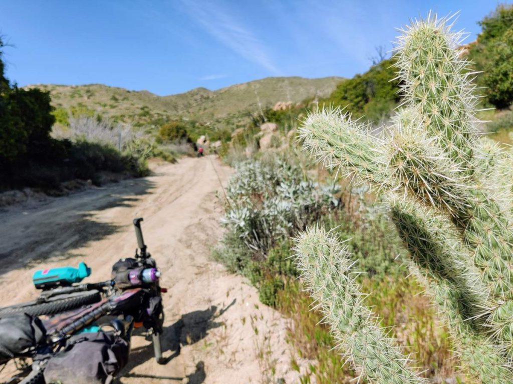

Loaded bike lies in dirt road with prickly cholla cactus in foreground
Just after turning right out of Grapevine Canyon

After six miles of gradual climbing, the route leaves the canyon. Within half a mile there is a nice flatish area with good campsites hidden amongst juniper and cholla (check carefully for spikes before setting up your tent!). We settled in here and had a clear, somewhat windy night, though not nearly as windy as our first. 
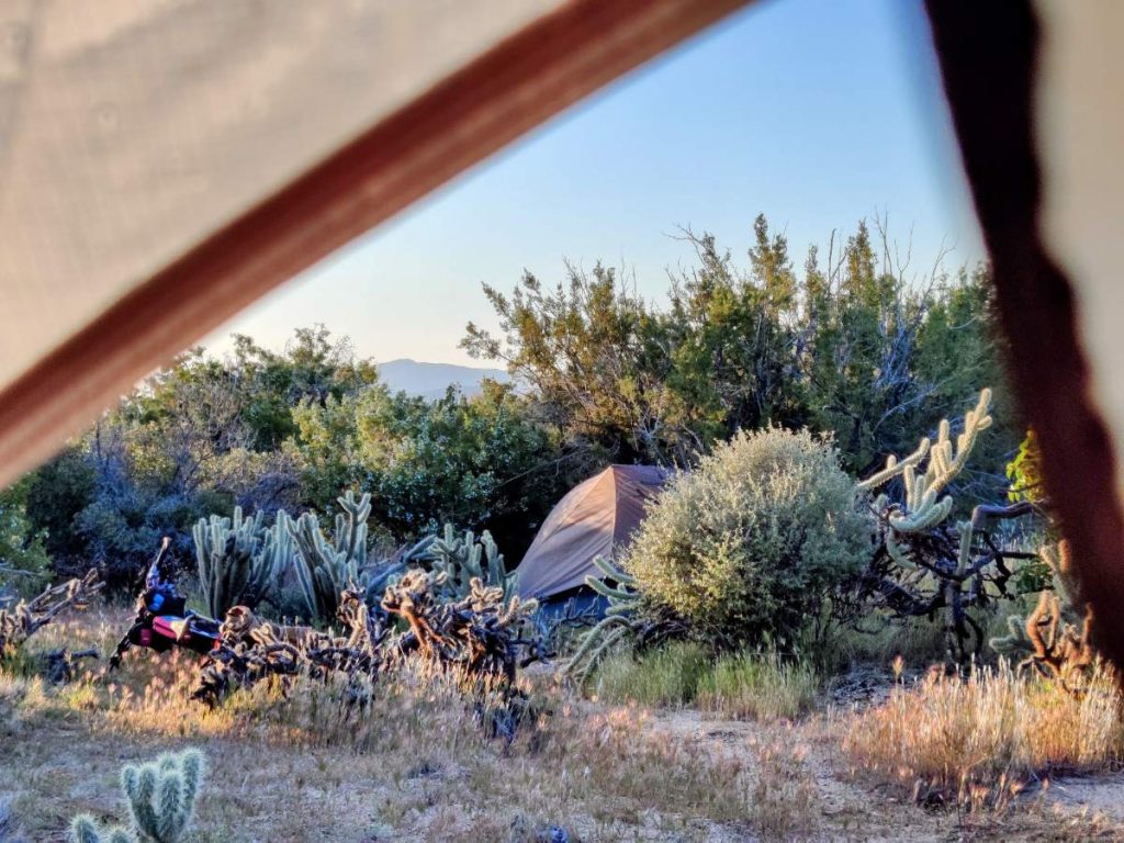

A bicycle and tent hidden amongst desert shrubs, with tent fabric in foreground
Looking out of my tent at my riding companion’s tent on the morning of day 4

Day 4 (half day)

After another chilly night we were up and ready to tackle the final few miles of undulating climbs. The first pitch was steep but the second two were more manageable. At the top we took a few minutes to enjoy the view and the sense of accomplishment, then turned right and started a fun dirt descent into Culp Valley.


Two bikes lean against dirt embankment beside a desert backroad
Getting close to the last bit of climbing on the route

At Montezuma Valley Road we turned right onto eight miles of smooth, curvy, windblown pavement dropping down to the desert floor. Once again we felt glad to be riding clockwise and not climbing this monster hill!


Cyclist pulled over in wide shoulder with views of brown desert floor ahead
Stopping to enjoy the views on the final descent to Borrego Springs

The traffic was fairly light and courteous and we were in good spirits, stopping at the pullouts and enjoying the views. The chilly wind had us adding layers, but as soon as we hit the bottom in Borrego Springs the heat had us stripping them off.

After loading up the bikes and cleaning up a bit in the bathroom behind the sheriff’s office (near the park), we enjoyed a celebratory lunch at Bighorn Burgers and Shakes before starting the long drive north.

Recommended?

Do I recommend this route? If you’re in the southern California area, definitely. It’s beautiful and interesting, well thought-out, and basically the biggest loop you can make using mostly dirt roads within Anza Borrego Desert State Park. It’s also one of the rare bikepacking routes that’s rideable all through winter, more or less.

That said, if I’m being honest, I don’t think this is a “destination route” to travel a long way for. Partly, it’s too short. It also lacks the more showy and spectacular scenery found on some of the best desert routes; the Grand Staircase Loop in southern Utah comes to mind.

If you’re looking for a much longer route in the same area, the SoCal Desert Ramble and Stagecoach 400 both overlap with the Fish Creek Wash section of the Anza-Hapaha Loop. The Ramble is easy to recommend and worth traveling for, in my opinion. The Stagecoach 400 requires more careful thought. Designed as a race route, it has sparse camping and water options in some parts and more road riding than some bikepackers will like.

More Bikepacking Resources

If you liked this post, you might also like these:

Or visit the bikepacking section for lots more!


Ride Report: Bikepacking the Anza-Hapaha Loop in Southern California

About the Author

Hi there, I’m Alissa, founder of Exploring Wild. I’ve traveled over 19,000 miles by bike and still can’t stop planning my next ride (and helping you plan yours). Pavement and panniers or singletrack and seat bag, I love it all. On my bike I feel free. Learn more about me here.

Shop Bikepacking Resources

Excited to try bikepacking but need help getting started? The Bikepacking Trip Planner Workbook can help you take the next step.


Ride Report: Bikepacking the Anza-Hapaha Loop in Southern California

Ride Report: Bikepacking the Anza-Hapaha Loop in Southern California

Bike resources in your inbox?

There’s more where this came from! Sign up here for occasional emails full of inspiration and information about bikepacking and bicycle touring.


Ride Report: Bikepacking the Anza-Hapaha Loop in Southern California

Ride Report: Bikepacking the Anza-Hapaha Loop in Southern California

Ride Report: Bikepacking the Anza-Hapaha Loop in Southern California

Ride Report: Bikepacking the Anza-Hapaha Loop in Southern California

Town Day Checklist!

Sign up to receive the free downloadable bikepacking town day checklist to help with your resupply stops:

    You’ll also receive occasional emails with other bikepacking and touring resources. I think you’ll like them, but you can unsubscribe at any time.

    Share the Adventure

    If you found this article helpful, please consider sharing so more people can benefit from it:

    The post Ride Report: Bikepacking the Anza-Hapaha Loop in Southern California appeared first on Exploring Wild.

    https://exploringwild.com/bikepacking-anza-hapaha-loop/?utm_source=rss&utm_medium=rss&utm_campaign=bikepacking-anza-hapaha-loop