Are you looking for an absurdly hard day hike in California? A quad destroying, foot pummeling, pre-dawn start, all-day sufferfest rewarding and challenging adventure? Or perhaps just some vicarious inspiration?
These hardest of the hard California day hikes aren’t for everyone, but if you put in the work to train and prepare they can be a memorable and confidence-building adventure. California is home to so much staggeringly beautiful terrain, from desert to high alpine and sometimes both in a single very long day. I’m a lifelong Californian who loves to put down big miles from time to time. I’ve hiked four of these trails, some as day hikes and some as backpacking trips, and the last is still on my bucket list.
What makes a day hike hard enough to qualify for this list? Typically it’s a combination of long miles and big elevation gain, sometimes mixed with other challenges like high altitude, heat, and limited water. Of course you can make anything into a hard day hike simply by simply packing in more miles, and ultra trail runners often cover 40 miles or more in a single day. For this list I’ve stuck to hikes of around 25 miles or less that can be completed in a single (very long) day at walking pace, centered around a notable summit to make all the hard work worthwhile.
Word of warning: These challenging California day hikes make for great inspiration, but please don’t attempt them unless you’re well-trained and thoroughly prepared. All these trails can be dangerous if you haven’t done your research or aren’t prepared to go the distance. Always carry the necessary safety essentials for an ambitious hike where there’s potential to be stuck out overnight, and know how to make the tough decision to turn back early if necessary. The trail will still be there later!
Related reading: How to Hike 20+ Miles in a Day
Mt. Whitney
Location: John Muir Wilderness, Eastern Sierra
Trailhead: Whitney Portal, near town of Lone Pine
Distance: 21 miles (out and back)
Highest elevation: 14,505 feet
Elevation gain: 6600 feet
Hiking season: July to September
Permit: required, and competitive
Summiting Mount Whitney is an iconic super-hard day hike to the summit of the highest California 14er and tallest peak in the entire contiguous 48 states. It’s so long and hard that many people prefer to tackle it as an overnight backpacking trip. If you are going to tackle Whitney in a single push you’ll need to start well before dawn and follow the weather forecast closely. The hiking route is non-technical but you’ll need to be well-acclimated and trained to handle so many miles of rocky uphill at high altitude. Once at the summit your work isn’t over… Don’t underestimate the quad-busting impact of the never-ending downhill!
Map and hike reports: Mt. Whitney Trail (AllTrails)
Highlights: summit the tallest mountain in the contiguous United States, unparalleled views of the High Sierra
Challenges: very very long day; stormy weather poses danger; high altitude makes for slow progress; patches of ice and snow common in early summer and late fall; popular trail with lots of hikers; permits are via lottery system and hard to get
Tips: Spend a couple days and nights at moderate altitude beforehand to acclimate and avoid altitude sickness. A pre-dawn alpine start is strongly recommended to give you enough time to summit and hike down, as well as best chances to avoid dangerous afternoon thunderstorms. Bring warm layers for the top; I was absolutely freezing up there in September! If you’re not on track to summit by your predetermined turnaround time, make the tough decision to turn around anyway.
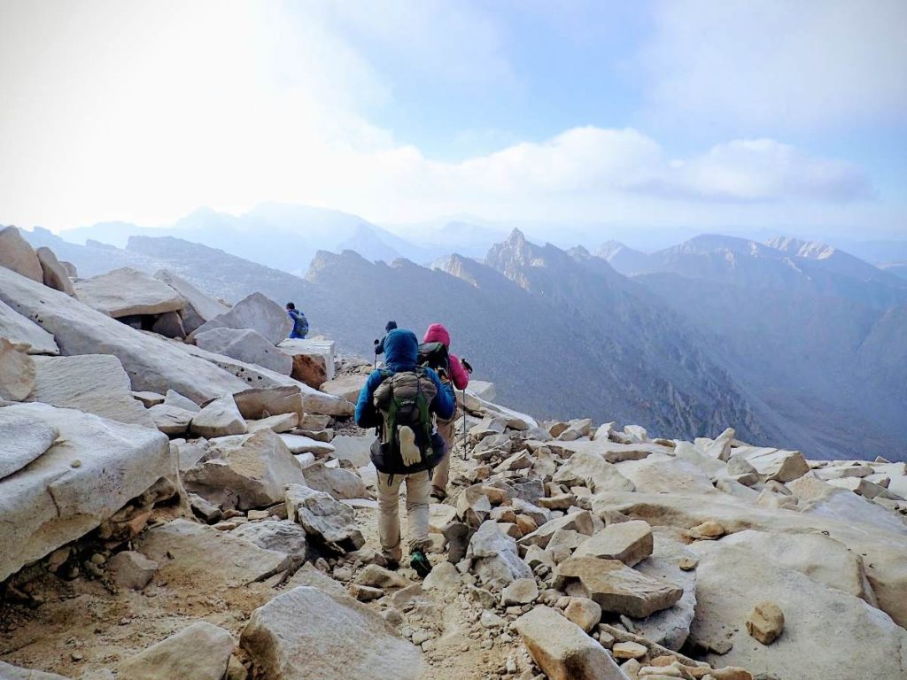
The Eastern Sierra scenery will help take your mind off how hard the Mt. Whitney Trail is.
Cactus to Clouds (Skyline Trail)
Location: Mount San Jacinto State Wilderness, southern California
Trailhead: Palm Springs Art Museum trailhead, in town of Palm Springs
Distance: 20 miles (out and partial back, ending at tram)
Highest elevation: 10,834 feet
Elevation gain: 10,715 feet
Hiking season: spring (ideally May) or fall (Oct – Nov)
Permit: free self-issued wilderness permit at Long Valley
Map and hike reports: Skyline Trail (AllTrails)
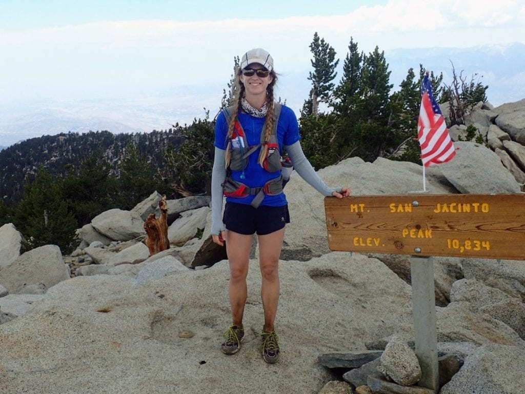
This absolute beast of a day hike, known as Skyline Trail or Cactus to Clouds, is unique for several reasons. You’ll experience both the desert floor (cacti and all) and an alpine summit in the same day. The elevation gain per mile is nearly unparalleled in the US; this hike is ALL about the climbing. Limited water and scorching temps at the bottom make this a committing route; you basically need to outrun rising desert temps as the sun rises. Mercifully you can choose to take a tram down instead of hiking the bulk of the descent, which your exhausted legs will surely thank you for as you kick back and enjoy the dramatic views over the desert floor you just hiked up from.
Highlights: hiking from desert to forest to alpine summit in a single day; expansive views over the desert floor; the biggest vertical gain you’ve probably ever experienced in a day hike; taking the tram down
Biggest challenges: extreme and relentless elevation gain; limited drinking water and intense heat; committing (turning around not advised due to heat); narrow seasonal window due to heat down low and snow up high
Tips: This day hike absolutely requires a pre-dawn start, because mid-day temps at the trailhead can easily top 100 F even in spring and fall. Carry at least 6 liters of water; there’s no refill until Long Valley. If you get tired, your best bet is to continue up to the tram rather than risk descending into the mid-day desert heat. On the day we hiked it topped 110 F down on the desert floor!
Learn more: Cactus to Clouds Hiking Guide
At the high point of Cactus to Clouds, still several miles to go back down to the tram.
Half Dome
Location: Yosemite National Park
Trailhead: Happy Isles
Distance: 16.5 miles (out and back)
Highest elevation: 8805 feet
Elevation gain: 5305 feet
Hiking season: May – October when cables are up
Permit: required (lottery) to continue past subdome to cables
Map and hike reports: Half Dome via JMT (AllTrails)
Highlights: stunning Yosemite scenery; unique and thrilling cable ascent
Biggest challenges: Cables to summit require a head for heights and a bit of upper body stamina. Getting a permit is hard and the trail is very busy.
Tips: Bring comfortable grippy shoes and work gloves to protect your hands on the cables. Do your research on how to safely tackle the cables section; there is fatal fall potential. You don’t have to ascend the cables if you’re not feeling it; even getting to the subdome is a big accomplishment! A short alternate route is to take the steeper (lots of stone stairs) Mist Trail either up or down for waterfall views.
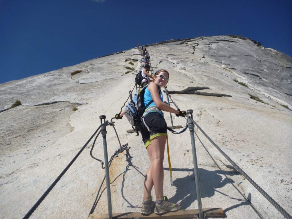
Do your research on the cables section before deciding to summit Half Dome.
Cone Peak (Sea to Sky)
Location: Ventana Wilderness, coastal central California
Trailhead: Vicente Flat Trailhead, at Kirk Creek Campground
Distance: 22 miles
Highest elevation: 5157 feet
Elevation gain: 6272 feet
Hiking season: year-round depending on weather; spring is ideal
Permit: none required
Map and hike reports: Cone Peak from Highway 1 (AllTrails)
The Sea to Sky route up Cone Peak is one of my personal favorite challenging California hikes. Typically you have to visit the Sierra for such impressive elevation gain, but Cone Peak is the highest coastal mountain in the contiguous 48 states. It stands at over 6200 feet elevation, less than five miles (as the crow flies) from the coast! The mileage and elevation gain of this hike are comparable to summiting Mount Whitney(!) though the lower elevation makes it feel easier. Like Whitney, Cone Peak is more often done as a multi-day backpacking trip to take the pressure off.
Highlights: summit the tallest coastal mountain in the contiguous 48 states; dizzying views over the scenic California coastline near Big Sur; relatively uncrowded trail with no permit requirements
Biggest challenges: trail is overgrown in places, including poison oak; very long mileage
Tips: Check Highway 1 status before going as landslides frequently close the road. Wear long pants and sleeves to protect you from scratches and poison oak on overgrown sections, and check trail conditions before hiking. Fill up with plenty of water at Vicente Flat because there is none after during dry seasons. Check your body and clothes for ticks after finishing.
Learn more: Cone Peak: Sea to Sky Near Big Sur
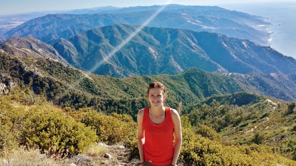
The views from the summit of Cone Peak are truly special. Nowhere else in the contiguous 48 states can you reach such high elevation so close to the ocean!
Shorty’s Well to Telescope Peak to Mahogany Flat
Location: Death Valley National Park
Trailhead: Shorty’s Well Road / Hanaupah Canyon Road
Distance: 22 miles (point to point)
Highest elevation: 11,043 feet
Elevation gain: approx. 11,500 feet
Hiking season: spring (can be hot) or fall (ideal)
Permit: none required
Map and hike reports:
This is it, the BIG one. Don’t try this crazy-hard day hike until you’ve done all the others! Starting in Badwater Basin at 243 feet below sea level, you’ll hike and scramble your way to the tallest summit in Death Valley National Park. This route shares some aesthetics with Cactus to Clouds in that you’ll be hiking from a desert floor to an alpine peak, but this one is even harder with plenty of off-trail travel and no one else around. For the hike described here you’ll need two vehicles, one parked on Westside Road near Shorty’s Well and the other at Mahogany Flat Campground. You could also do an out-and-back from Mahogany Flat (easier) or from Shorty’s Well (even harder, not advised!).
Highlights: hike from hear the lowest point in North America to 11,000+ feet; almost as much elevation gain as climbing Everest; remote and solitary experience
Biggest challenges: two car shuttle required to hike point to point; extreme temperature difference; short hiking window due to heat at bottom and snow at top; limited water; potential for challenging weather at top; long sections of dirt road walking; off-trail route finding; very remote with possibly no other hikers
Tips: If you’re taking this hike on, you should already know all the tips! Start very early, take reliable GPS navigation for the off-trail sections, prepare for extreme temperature differences bottom to top, and good luck.
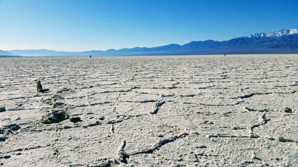
The Salt Flats of Badwater Basin, the lowest spot in North America, are the starting point for this absolutely epic day hike with over 11,000 feet of elevation gain.
Other Hard Day Hikes in California
The five hikes highlighted above are famous and bucketlist-worthy, but they are far from the only challenging hikes in California. For those seeking more under-the-radar options, here are some lesser-known but still totally beastly options.
San Antonio Ridge: One of the burliest routes in the rugged San Gabriel Mountains near Los Angeles, this incredible traverse includes some serious scrambling and cross-country travel with a mind-blowing 11,000+ feet of gain in 22 miles!
Old Mt. Baldy to Three T’s Loop: Another San Gabriel Mountains route, but more approachable than San Antonio Ridge. You can also explore other ways to link up the many formidable peaks in the area, such as this route.
Mount Shasta via Avalanche Gulch: More of a mountaineering route than a hike, Shasta requires technical gear and skills and shouldn’t be attempted without them. However, if you have the skills or hire a guide this route takes you over 7000 feet up to the top of a unique volcanic California 14er.
This list is a work in progress. Have your own favorite hard hike to add? Let me know in the comments below!
Essential Gear for Hard Day Hikes
It’s always important to pack thoughtfully for hiking, but especially when tackling ambitious mega-hikes like the ones above. Trails like these tend to span wide temperature ranges, require hiking in the dark, and carry a risk of accidentally being caught out overnight. Here’s the gear I recommend at minimum for a long day hike:
- hiking poles to help with rocky trails and tired legs
- water filter so you can refill from natural sources
- headlamp and spare batteries
- GPS navigation (could be a smartphone app), backup navigation, and possibly a power bank
- adequate water capacity (sometimes up to 6 liters)
- electrolytes for hot hikes
- lots of food
- satellite communicator: Garmin InReach or SPOT
- warm and rain layers
- sun protection: sunscreen, hat, sunglasses
- emergency bivy in case of bad weather or unplanned night out
- small first aid kit
More Hiking Resources
About the Author
Hi there, I’m Alissa, founder of Exploring Wild. I’ve had the pleasure of hiking the Arizona Trail, Colorado Trail, John Muir Trail, Tahoe Rim Trail, and countless shorter amazing trails throughout the US and abroad. I love solitude, big views, and a good lightweight gear setup. Learn more here.
Hiking resources in your inbox?
There’s more where this came from! Sign up here for occasional emails full of inspiration and information about backpacking and hiking.
Share the Adventure
If you found this article helpful, please consider sharing so more people can benefit from it:
The post From Desert to Alpine, 5 Really Hard Day Hikes in California appeared first on Exploring Wild.
https://exploringwild.com/hard-day-hikes-california/?utm_source=rss&utm_medium=rss&utm_campaign=hard-day-hikes-california
 CampingSurvivalistHuntingFishingExploringHikingPrivacy PolicyTerms And Conditions