Hiking in Banff was a long-time bucket list trip for me and my husband, so we were super excited to finally get a chance to visit in the summer of 2023. Home to incredible vistas, turquoise alpine lakes, tons of wildlife, icy glaciers, and some of the most stunning hiking trails in the world, we couldn’t wait to discover this outdoor paradise.
On our agenda for our visit, was to explore the best hikes in Banff National Park from the popular (but very scenic) routes around Lake Louise to the otherworldly trails along the Icefields Parkway and more.
In this blog post, we share our top picks for the best Banff hikes based on scenery, unique trail features, and more. No matter what your skill level or interests, you’re sure to find a great hike that’s perfect for you!
Banff National Park Hiking Areas
Before I get into what hikes to do, it’s important to know that Banff National Park is enormous – over 2,500 square miles. We needed to plan our hikes based on what region they were in.
On our trip, we had a chance to explore the following areas:
- Lake Louise & Moraine Lake Area
- Bow Valley Parkway Area
- Icefields Parkway Area
 Banff National Park can be broken into three different areas for hiking
Best Hikes Near Lake Louise & Moraine Lake
Lake Louise and Moraine Lake are glacial lakes in the central part of Banff National Park. They are one of the most popular tourist destinations in Canada and are famous for their turquoise waters and dramatic backdrops.
We found that due to their popularity, visiting Lake Louise and Moraine Lake requires advanced planning – especially for parking. We had a full day to spend in the Lake Louise area so we combined several smaller hikes which I go into detail about below.
Lake Louise Parking
The Lake Louise parking lot fills up extremely quickly (as early as 7 am), especially in the summer months. It typically stays full throughout the day and is paid during peak season.
When we visited, we arrived at the parking area pretty early – around 5:45 am – to watch the sunrise and were able to snag a parking spot. The paid parking was in effect from 7 am to 7 pm so we still had to pay the parking fees during those hours. You can check parks.canada.ca/BanffNow for real-time parking status.
If you are not an early riser or would like to avoid the hassle of finding parking, you could also take the Parks Canada shuttle or the Roam Transit shuttle. Advance reservations are required for all shuttles departing the Park and Ride. The reservations fill up really really fast. Be sure to check parks.canada.ca/banff-transit for transit and shuttle options.
Moraine Lake Parking
Starting in 2023, Moraine Lake Road has been closed to personal vehicles. So the only option to get here is either by the Parks Canada Shuttle, Roam Transit, or private hiking/biking company tours.
We wanted to watch the sunrise in Moraine Lake and the only viable option to watch sunrise in the park in summer is via a Private Company Tour. We booked a sunrise tour from Moraine Lake Bus Company.
1. Lake Louise Lakeshore
Trail Basics
- Distance: 2.8 miles
- Type: Out & Back
- Elevation Gain: 121 ft
- Time: 1 hour
- Difficulty: Easy
- Trailhead: Lake Louise Parking Lot
- Dogs allowed? On leash
- Map: AllTrails
This is an easy walk we did along the lakeshore of Lake Louise. We enjoyed the many viewpoints and benches throughout the path and the backdrop of Victoria Glacier on the mountains behind the lake is spectacular.
There are usually lots of people at the start of the lakeshore but the crowds thinned out the farther we went.
It’s a great walk to stretch your legs after a long drive or as an easy hiking option as a warm-up for the rest of your visit. If you want to make the most of your visit, wake up early and catch the sunrise at the lakeshore!
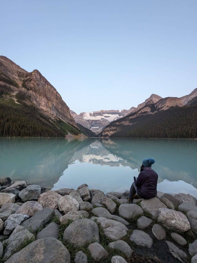
Enjoy views of Victoria Glacier on the Lake Louise Lakeshore trail | Photo credit: Harshita Kasera
2. Lake Agnes Trail
Trail Basics
- Distance: 4.6 miles
- Type: Out & Back
- Elevation Gain: 1,427 ft
- Time: 3 hours with ample breaks
- Difficulty: Moderate
- Trailhead: Lake Louise Parking Lot
- Dogs allowed? On leash
- Map: AllTrails
The trail to Lake Agnes begins at the Lake Louise lakeshore. The elevation on the way up is moderately steep but, it’s so worth it! At the top, we were rewarded with beautiful views of Lake Agnes.
However, the most exciting part of the hike for me was the Lake Agnes Tea House. This little building is a historic tea house that was built in 1901 by the Canadian Pacific Railway as a refuge for hikers and to provide refreshments.
The Tea House is open from early June through October and is located in a stunning setting, with views of Lake Agnes and the surrounding mountains.
Due to its popularity, the tea house gets crowded and there is a long line later in the day. Since we were early to this hike (we reached the top around 8 am) we didn’t have to wait too long. The tea and the baked goods were delicious.
Tip: Be sure to carry some cash for the Tea House as the internet is pretty flaky so your credit card may not work.
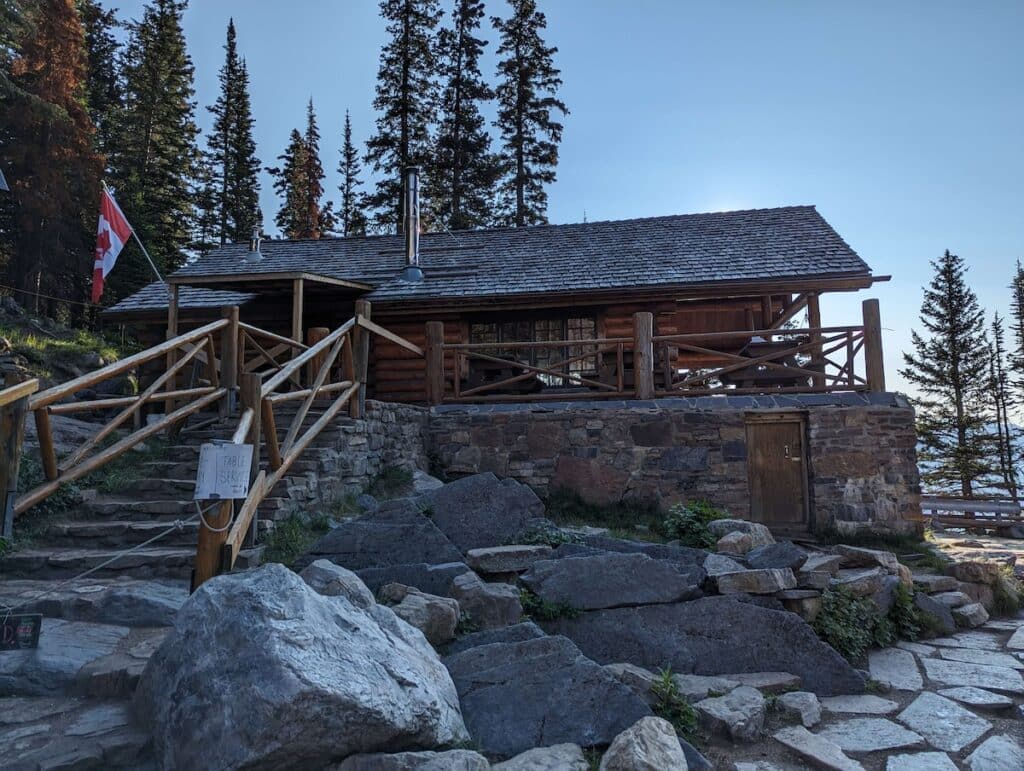
The Lake Agnes Tea House is a great place to stop in for a warm drink or snack
The tea house is a great place to relax and take a break before heading back down or you can continue on to other trails that start from here like Beehive Circuit, Devils Hike, and Plain of Six Glaciers.
After taking a break at the Lake Agnes Teahouse, we continued to the Beehive Circuit.
3. Beehive Circuit
Trail Basics
- Distance: 7.3 miles
- Type: Loop
- Elevation Gain: 2,486 ft
- Time: 5 hours with ample breaks
- Difficulty: Challenging
- Trailhead: Lake Louise Parking Lot
- Dogs allowed? On leash
- Map: AllTrails
We extended the Lake Agnes Trail for an additional 2.7 miles by adding two viewpoints – Little Beehive and the Big Beehive. We also passed the Beehive monolith, which towers over Mirror Lake
Both of these viewpoints are spectacular – we enjoyed stunning panoramic views of Louise Lake, the Victoria Glacier, and many of the park’s most iconic mountains including Mount Victoria, Mount Temple, and Mount Assiniboine.
After the Beehive Circuit, we continued further to the Plain of Six Glaciers Trail.
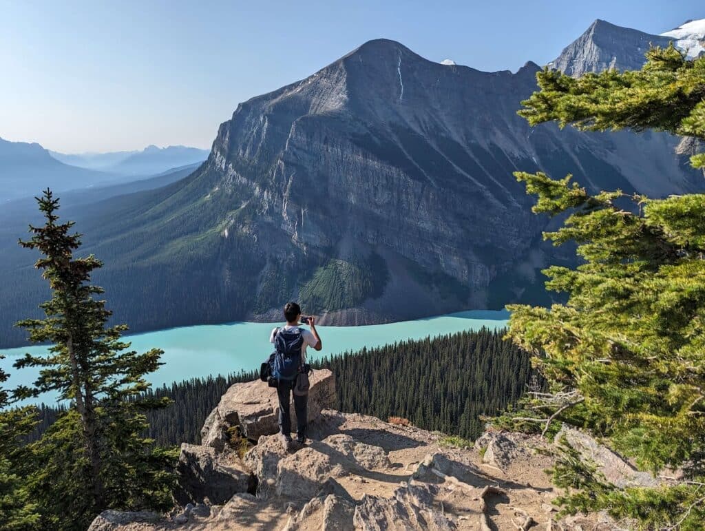
The stunning views at Beehive Overlook | Photo credit: Harshita Kasera
4. Plain of Six Glaciers Trail
Trail Basics
- Distance: 9.1 miles
- Type: Out-and-back
- Elevation Gain: 1,929 ft
- Time: 5 hours with ample breaks
- Difficulty: Moderate
- Trailhead: Lake Louise Parking Lot
- Dogs allowed? On leash
- Map: AllTrails
This trail offers stunning views of the Plain of Six Glaciers, a large area of alpine meadows and glaciers located to the south of Lake Louise.
There are a few steep sections, but overall I didn’t find the hike to be too challenging. The views are amazing and we felt like we entered a totally different world!
There is another tea house called the Plain of Six Glaciers Tea House at the end of this trail. Stopping for a warm drink and snack was definitely a highlight for us. They serve a variety of food options and their tea choices were very impressive. It is a good place for a lunch break – we enjoyed a delicious hummus sandwich and a brownie.
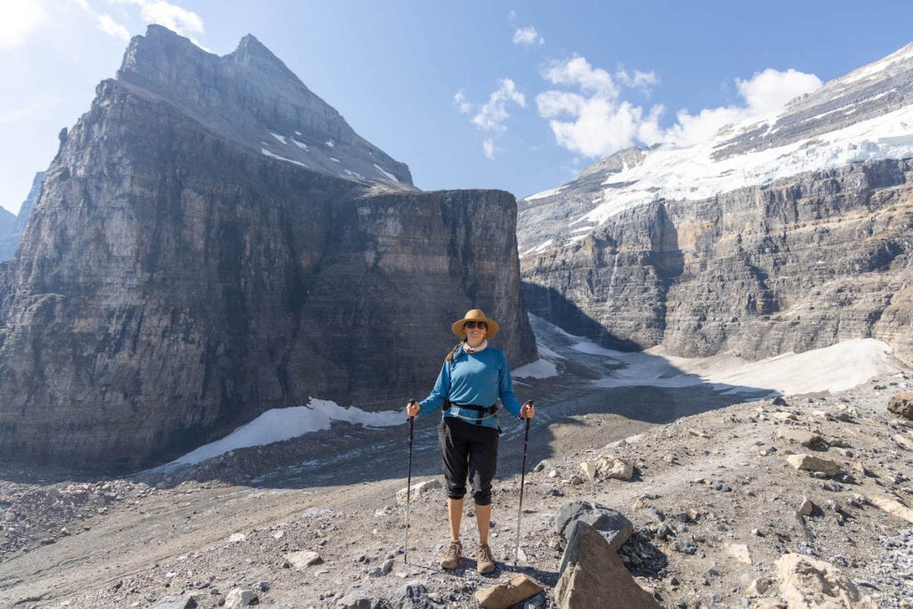
Kristen near the end of the Plain of Six Glaciers Trail
5. Plain of Six Glaciers and The Beehives
Trail Basics
- Distance: 12.4 miles
- Type: Loop
- Elevation Gain: 3,835 ft
- Time: 8 hours with ample breaks
- Difficulty: Challenging
- Trailhead: Lake Louise Parking Lot
- Dogs allowed? On leash
- Map: AllTrails
This hike combines the above 4 hikes in the Lake Louise Area: Lake Louise Lakeshore, Lake Agnes Trail, Beehive Circuit, and Plain of Six Glaciers Trail.
We did it as one hike and spent an amazing day around Lake Louise. If you have a full day and really want to experience the best of Lake Louise hiking, this is the one hike I highly recommend.
You’ll get to enjoy the amazing views of Lake Louise from the Beehive viewpoints, take breaks at the tea houses, and see the beautiful glaciers and mountains on the trail.
Be sure to bring lots of snacks and water as well as your day hiking essentials.
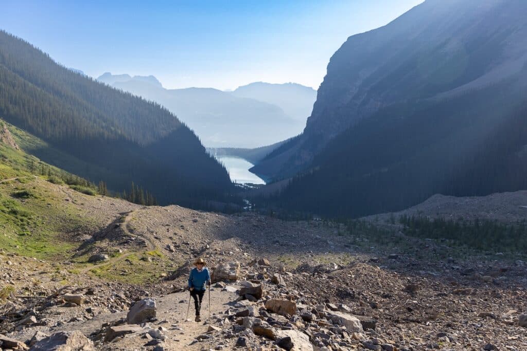
Kristen also hike the Plain of Six Glaciers Trail during her Icefields Parkway road trip
6. Fairview Lookout Trail
Trail Basics
- Distance: 1.4 miles
- Type: Loop
- Elevation Gain: 528 ft
- Time: 1 hour
- Difficulty: Easy
- Trailhead: Lake Louise Parking Lot
- Dogs allowed? On leash
- Map: AllTrails
If you are looking for a short hike in the Lake Louise area this trail is perfect. The hike is in the forest, so there isn’t much to see until you get the viewpoint.
We didn’t get a chance to do this hike as we wanted to do the longer hikes, but it’s a good option for hikers who don’t want to go as far while still getting some great views.
Read More
Planning a road trip?
7. Rockpile Trail to Moraine Lake Overlook
Trail Basics
- Distance: 0.5 miles
- Type: Out-and-back
- Elevation Gain: 32 ft
- Time: ~10 minutes
- Difficulty: Easy
- Trailhead: Moraine Lake Parking Lot (shuttle required)
- Dogs allowed? On leash
- Map: AllTrails
The Moraine Lake viewpoint is an incredibly popular destination for photographers and it’s an easy spot to access via the short Rockpile Trail. We reached the overlook before sunrise and were amazed to see so many people there already.
Despite the crowds, I still can’t get over the view of this picture-perfect lake. The half-mile walk is definitely worth getting out of the car for.
The Moraine Lookout from Rockpile Trail is extremely popular, but for good reason!
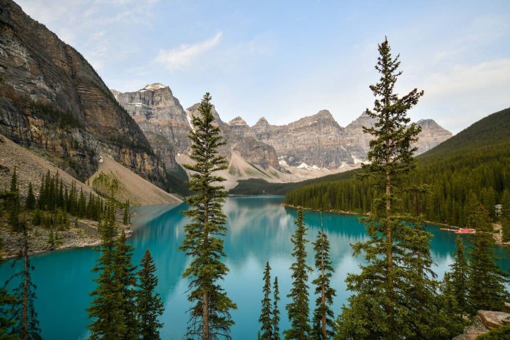
8. Moraine Lake Shoreline Trail
Trail Basics
- Distance: 2.4 miles
- Type: Out-and-back
- Elevation Gain: 643 ft
- Time: 1.5 hours
- Difficulty: Easy
- Trailhead: Moraine Lake Parking Lot (shuttle required)
- Dogs allowed? On leash
- Map: AllTrails
Moraine Lake Shoreline Trail is an easy trail along the shoreline of Moraine Lake. During the summer season, canoes can be rented from Moraine Lake Lodge for a day out on the water. This is a great way to experience the lake (especially for families) without putting in much work.
9. Consolation Lakes Trail
Trail Basics
- Distance: 4.6 miles
- Type: Out-and-back
- Elevation Gain: 1,059 ft
- Time: 2.5 hours
- Difficulty: Challenging
- Trailhead: Moraine Lake Parking Lot (shuttle required)
- Dogs allowed? On leash
- Map: AllTrails
Consolation Lakes Trail is a gorgeous hike that branches off from the Rockpile Trail to the left, just before the climb to the top of the rock pile.
The hike traverses through a very rocky section and can be a bit tricky to navigate as the rocks and boulders can be loose, smooth, and very large.
Bears are common in this area so carrying a bear bell and bear spray and hiking in groups is recommended.
Bow Valley Parkway Hikes
The Bow Valley Parkway is a scenic highway that runs parallel to the Trans-Canada Highway between Banff and Lake Louise.
10. Johnston Canyon to Upper Falls
Trail Basics
- Distance: 3.3 miles
- Type: Out-and-back
- Elevation Gain: 862 ft
- Time: 1.5 – 2 hours
- Difficulty: Moderate
- Trailhead: Johnston Canyon Parking Lot
- Dogs allowed? On leash
- Map: AllTrails
Johnston Canyon Trail is an extremely popular trail in Banff National Park. It’s a relatively easy hike, so it can be enjoyed by nearly everyone.
The trail winds through the canyon created by the flow of Johnston Creek. On the way, we saw many waterfalls – the two most popular are Lower Falls and Upper Falls.
Lower Falls
The hike to the Lower Falls is relatively easy on a boardwalk. There is a small cave that we walked through to get a closer view of the falls. It gets pretty crowded and you may have to stand in a line so it is best to arrive early.
When we visited in summer (the first week of July), we didn’t have to wait in huge lines since we arrived by 7:30 am. That being said, we still had to line up for about 15 minutes even at that early morning hour.
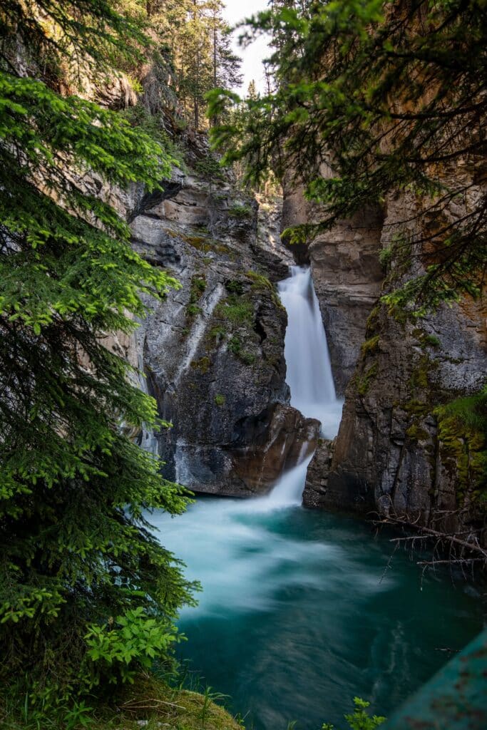
Lower Johnson Falls | Photo credit: Harshita Kasera
Upper Falls
The hike to the Upper Falls is also on a well-maintained trail but it is much farther up the trail than Lower Falls. I found this part of the trail to be less crowded and there are multiple areas to view the falls from a different perspective.
Again, depending on which time of the year you visit, you might have to wait in line for a photo op. We waited for about 10 minutes, but it was worth it!
There is an extension to go further up the trail to Ink Pots. This would add another ~3.5 miles to the trip.
A note on parking: The parking near the trailhead is limited. I recommend starting early in the morning for this hike (no later than 7:30 am) to secure a parking spot and have a pleasant experience. We arrived here by 7 am and managed to find a parking spot.
11. Bow Falls Viewpoint
Trail Basics
- Distance: 1.7 miles
- Type: Out-and-back
- Elevation Gain: 167 ft
- Time: ~30 minutes
- Difficulty: Easy
- Trailhead: Banff town
- Dogs allowed? On leash
- Map: AllTrails
The Bow Falls Viewpoint trail begins in the town of Banff, just at the south base of the pedestrian bridge across the Bow River. It was a quick and pretty trail we did within walking distance from the center of town.
This is one of the easiest and shortest hikes in Banff, but it’s still very scenic and worth the small effort. We brought a cup of coffee from town and sat on one of the benches tucked alongside the river to enjoy the views of the falls.
12. Johnson Lake
Trail Basics
- Distance: 1.8 miles
- Type: Loop
- Elevation Gain: 226 ft
- Time: ~45 minutes
- Difficulty: Easy
- Trailhead: Johnson Lake day use area
- Dogs allowed? On leash
- Map: AllTrails
Johnson Lake is an easy hike that takes you through forests and meadows to a beautiful lake. We found the trail to be well-maintained and easy to follow.
The trail begins at the Johnson Lake day-use area and ample parking is available. There are several picnic tables at the lake, making it a great spot for a picnic lunch.
13. Two Jack Lake
Trail Basics
- Distance: 3 miles
- Type: Out-and-back
- Elevation Gain: 741 ft
- Time: 2 hours
- Difficulty: Moderate
- Trailhead: Two Jack Lake Parking
- Dogs allowed? On leash
- Map: AllTrails
This is another easy hike around the town of Banff with beautiful views of the Two Jack Lake.
If you have a paddleboard or kayak, it’s also a great lake to get out on the water. The views of Mount Rundle over the lake are breathtaking!
Icefields Parkway Hikes
Icefields Parkway is one of the most scenic drives in the world with stunning views of the Canadian Rockies and a handful of glaciers. The parkway connects the town of Jasper in the north to the town of Lake Louise in the south.
There are numerous scenic viewpoints and hikes along this parkway and we got a chance to do two of the best (although there are many amazing hikes here).
14. Bow Glacier Falls
Trail Basics
- Distance: 5.5 miles
- Type: Out-and-back
- Elevation Gain: 925 ft
- Time: 3 hours
- Difficulty: Moderate
- Trailhead: Bow Lake Lodge
- Dogs allowed? On leash
- Map: AllTrails
Bow Glacier Falls is one of the many spectacular waterfalls on an epic drive along the Icefields Parkway. This was one of my favorite trails on the trip as it features an impossibly blue lake, gorgeous waterfalls, views of majestic mountains, and glaciers.
Fun fact: Bow Glacier Falls is the largest waterfall along the Icefields Parkway
We started the trail at Num-Ti-Jah Lodge where we grabbed a quick bite to eat at the cute cafe. The start of the trail was mostly flat and easy then it gets harder towards the second half as we neared Bow Glacier Falls.
The trail has so many beautiful waypoints to admire so take your time exploring each of them!
The trail runs along the shores of Bow Lake where the panoramic views around the lake are gorgeous. Crowfoot Mountain rising from the shores of the lake looks stunning. We crossed the Bow River and reached the never-ending stairs along the canyon, which I thought were the hardest part of the hike.
After the stairs, we walked into a boulder field left by glaciers. Eventually, we reached the incredible Bow Glacier Falls
The return trip felt like a completely different journey when we looked over Bow Lake from above.
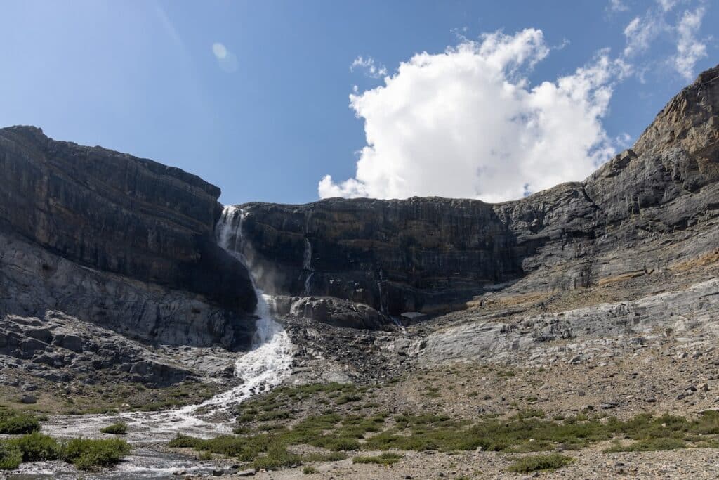
The hike to Bow Glacier Falls was one of my favorite trails in Banff National Park
15. Peyto Lake
Trail Basics
- Distance: 1.5 miles
- Type: Loop
- Elevation Gain: 305 ft
- Time: ~45 minutes
- Difficulty: Moderate
- Trailhead: Bow Summit Peyto Lake parking
- Dogs allowed? On leash
- Map: AllTrails
Peyto Lake is my favorite lake in Banff National Park and my favorite stop on the Icefields Parkway, despite how popular it is. If you are planning to drive the Icefields Parkway, this lake is one of the must-stops! This stunning turquoise-colored glacier lake is picture-perfect.
First viewpoint: This part of the trail is paved and the hike is short. There is a viewing platform with multiple different viewpoints of the lake. You can also choose to just do this 0.8 mi short hike.
Panorama viewpoint: This part of the trail has poor signage so be sure to have a trail map or hiking app downloaded to your phone. It is less busy compared to the first viewpoint and the additional walk is definitely worth it.
P.S. – Can you figure out what the lake looks like from the top? (hint: woof woof).
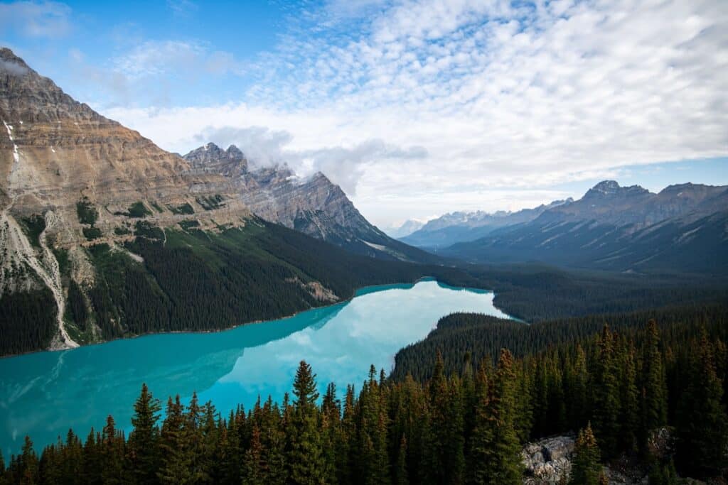
Stunning views of the turquoise-colored Peyto Lake
Tips for hiking in Banff National Park
The hiking trails around Banff National Park are incredibly stunning, but it’s important to make sure you’re prepared. Here are my top tips for hiking in the area:
- Plan your hike: Choosing a hike that is appropriate for your fitness level, experience, and time of the year is really important. Always make sure to check the trail conditions and make sure the hike is open. The Official Parks Canada website is a great resource for up-to-date information.
- National Park Pass: You must have a valid national park entry pass. Check out the Parks Canada Passes, Permits, and Fees page to get a list of stores where you can get the pass apart from the National Park Entrance Station. I highly recommend getting it before entering the park to avoid waiting in line at the entrance.
- Be prepared for changing weather: The weather in the Canadian Rockies changes quickly, so be sure to pack layers.
- Always carry hiking essentials: Day hiking essentials include food, water, sunscreen, a hat, sunglasses, rain gear, and a first-aid kit.
- Always stay on the trail: This helps to protect the environment and prevent accidents.
- Leave no trace: Pack out everything you pack in and leave the trails as you find them. Learn more about the Leave No Trace Principles.
- Be aware of wildlife: Banff National Park is home to bears, bighorn sheep, elk, and other wildlife. Be sure to hike in groups and make noise to avoid startling animals. Carry bear spray, and many trails have a recommended group size for bear safety, so please make sure to follow these guidances.
FAQs About Hiking in Banff
When is the best time to hike in Banff? The best time of year to hike in Banff National Park depends on personal preference and what kind of experience you want. My husband and I wanted a warm and dry climate so we chose to visit Banff in July. It was the peak tourist season so it was definitely crowded, but we planned our trip in advance. We woke up pretty early each day (think: sunrise) to avoid the crowds.
– Summer is great if you’re looking for a warm and dry climate. Be prepared for crowds, and visit later in summer for fewer bugs.
– Spring and fall months have a more moderate climate with fewer crowds. In Spring some of the trails are inaccessible due to snow pack and avalanche conditions. Fall is an opportunity to experience the world-famous larches changing color.
– Winter is beautiful with views of snow-capped peaks and a winter wonderland.
What is the most beautiful hike in Banff? This is a tough one because there are so many beautiful hikes in Banff! My favorite hike, though, was Bow Glacier Falls for the incredible scenery, turquoise-colored lakes, and a gorgeous waterfall.
How many days do I need to explore Banff? There is a ton to see and do in Banff, so you could easily spend weeks here. My husband and I had 10 days to explore and that felt like enough time to fit in everything we wanted to see and do. I recommend at least 5 days in Banff National Park if you want to check out the best hikes.
Are reservations required? I highly recommend making reservations for hotels and campgrounds because Banff does get very busy, especially in the summer. You’ll also need to make reservations for the Parks Canada Shuttle to Lake Louise and Moraine Lake.
Planning an adventure to British Columbia and Alberta? Here are a few more places worth adding to your itinerary:
Save this post to Pinterest
I hope this guide helps you in planning an unforgettable trip filled with the best hikes in Banff National Park. What are your favorite hikes in the Park? Which ones would you like to do? Leave a comment below!
The post 15 Best Hikes in Banff National Park For Spectacular Scenery appeared first on Bearfoot Theory.
https://bearfoottheory.com/best-hikes-banff-national-park/
 CampingSurvivalistHuntingFishingExploringHikingPrivacy PolicyTerms And Conditions