× CampingSurvivalistHuntingFishingExploringHikingPrivacy PolicyTerms And Conditions
Subscribe To Our Newsletter

Bikepacking Roots and Orogenesis Release Lost Sierra Bikepacking Route (added to my bucket list)

My bikepacking bucket list just got a little longer! California’s rugged Lost Sierra region is high on the list of places I long to spend more time, and Bikepacking Roots and the Orogenesis Collective — more on them below — just quietly published this little “ride of the month” that I think deserves a shoutout.

The Lost Sierra, for those unfamiliar, is a wonderfully rugged and under-the-radar (shhh, don’t tell) region of the Sierra Nevada mountains north of Truckee. When the unrelenting crowds of the Tahoe Basin threaten to suck all the good vibes out of your mountain vacation, head north to towns like Downieville, Taylorsville, and Quincy to experience what the Tahoe region should be like, and perhaps might have once been.

Related: Lost Sierra Adventure Guide

A rich history of gold mining has left its mark on these mountains, and more recently, logging. But in some places the region is reinventing itself within the outdoor recreation industry. It’s now home to PCT resupply towns, endless National Forest roads and moto trails, and increasingly, mountain bike trails.

The best-known fixture of the Lost Sierra mountain bike scene is the Downieville Downhill, a race / party I’ve attended twice (as a spectator) just to marinate in the bike vibes, be awed by the athletes, and drink beer by the river. It’s entirely possible that I hold the record for slowest shuttled downhill run on that course, performed over an entire leisurely afternoon on the old hardtail I was using to commute to work at the time.


Mountain bikers sit beside their bikes in front of a small town grocery store


The grocery store in Downieville, a resupply stop on the route.

So I was excited to see Downieville feature prominently as a resupply stop on the Lost Sierra Bikepacking Route. It comes just after a ripping unpaved downhill that I stupidly once drove up in my Honda CR-V (I mean, it’s called Galloway Street, how bad can it be?) in order to ride the dirt forest roads at the top. I’ve been wanting to explore bikepacking options near Downieville ever since, and I’m glad the Orogenesis Collective beat me to it.

Related: Bikepacking in California: Route Ideas in Every Region


Touring bike on extremely rocky dirt road


My touring bike (not the right choice) and I exploring one of many old “roads” criss-crossing the mountains near Downieville (not on the route in question, don’t worry).

The Orogenesis Collective

If you’re a bikepacker who hasn’t heard of the Orogensis project, it’s worth taking a look. The term refers to the geologic process of mountain building, a fitting image for this epic, audacious, and presumably (at times) glacial-paced effort.

The goal: Create “the world’s longest mountain bike trail,” over 5000 miles of more or less uninterrupted singletrack spanning from the US-Canada border all the way to the tip of the Baja Peninsula. The tagline “A new way on old ground” celebrates the project’s goal of connecting riders to millions of years of history — geological, ecological, and cultural / indigenous — underpinning their passage.

As a sub-project of Bikepacking Roots, this ambitious undertaking has some real momentum behind it. A large portion of the work has already been done in the form of researching, scouting, cleaning up, and linking up existing stretches of trail. As of 2022 I believe there were only a couple hundred miles of gaps where more intense efforts are needed.

If this all intrigues you, consider donating to the project! Because we all need 5000 miles of singletrack on our bikepacking bucket lists to keep things interesting.

Related: Five Long Work-in-Progress Bikepacking Routes in the U.S.

Lost Sierra Bikepacking Route

Ok, so what’s the deal with this 250-mile loop just published by Matt McCourtney at Bikepacking Roots and the Orogenesis Collective? They say the Ride of the Month series features trips “along Orogenesis,” though we don’t know which part of the loop (if any) is exactly on the planned route. But we do know the eventual Orogenesis route will pass through this area, as it most definitely should.

Though Orogenesis focuses on singletrack, this short loop is mainly a gravel route. So it should be accessible to a wide range of riders, but don’t underestimate it! The terrain in this region, I know from experience, is burly. The route has nearly 25,000 feet of climbing spread along its 250 miles, including a 4500 foot climb out of Downieville.
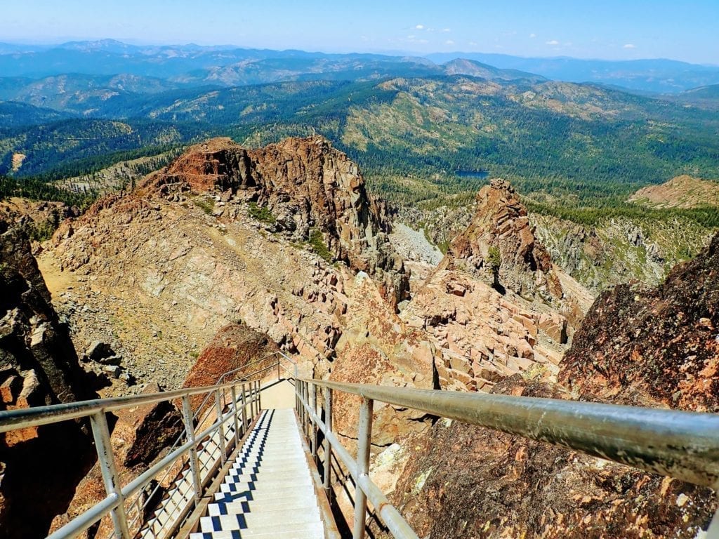


Looking down steep metal stairs from lookout tower with view of mountain range in the Lost Sierra


The Sierra Buttes tower, just a short hike from the high point of the climb from Downieville, is worthwhile reward for 4500 feet of climbing.

The thing I love most about this region is its seemingly endless National Forest land. As Matt’s route description says, there is “unlimited dispersed camping” along these dirt, gravel, and deteriorating paved roads. There should be plenty of water too, and easy enough logistics thanks to small towns along the route.

The route description says “The route is best broken up into 5 days, with about 60 miles and 6000k of vert per day.” Say what?! Though I’ve done it before and will do it again, I venture to say 6000 feet of climbing day after day after day is a bit much for the average recreational bikepacker.

If I were to ride this route (and I hope I will), I would probably aim for 7-8 days. Gotta leave time for ice cream, beer, and river soaks along the way!

Summer is the riding season for this route, but the high points at 7000+ feet elevation could feasibly hold snow into late June or early July. And by then, the low-lying stretches might be cooking. This won’t be a physically easy route, but compared to the Orogenesis singletrack epic I suppose it’s a cruisy long weekend lark.

I’m so happy to see the growth of bikepacking in this area, which clearly has loads of potential. Something about the Lost Sierra feels like the epitome of summer vacation to me, and this loop is now firmly lodged near the top of my short routes wishlist. Thanks Matt and Orogenesis!

Other Routes in the Area

Over the last few years there have been multiple bikepacking-related efforts afoot in the Lost Sierra. Though this route is currently the most extensive developed option, there are two other projects worth a look.

First, bikepacking.com and Nick Jenson recently published the 105-mile Lost Sierra Loop. It overlaps briefly with the 250-mile Lost Sierra Bikepacking Route between Quincy and Taylorsville but otherwise forges its own equally demanding path. If you want to get out there but can’t spare 5+ days, definitely check it out.

Second and more abstract is the Sierra Buttes Trail Stewardship’s Connected Communities project, which both the above bikepacking routes cite as inspiration. In fact Matt, the creator of the Lost Sierra Bikepacking Route, is a board member. This long-term project “aims to stimulate the economies of rural communities by improving trail access” around and between fifteen different towns.

With the planned multi-use trails being open to bikers as well as hikers, equestrians, and even motos, this project is the epitome of the region’s efforts to reinvent itself as an outdoor recreation destination. Though it won’t be finished any time soon, I’ll have my eye on it for sure!

In the meantime, I’m already looking at my calendar to see when I might squeeze in the Lost Sierra Bikepacking Route this summer.

More Bikepacking Resources

If you liked this article, you might also enjoy these:

Or visit the bikepacking section for lots more!


Bikepacking Roots and Orogenesis Release Lost Sierra Bikepacking Route (added to my bucket list)


About the Author

Hi there, I’m Alissa, founder of Exploring Wild. I’ve traveled over 19,000 miles by bike and still can’t stop planning my next ride (and helping you plan yours). Pavement and panniers or singletrack and seat bag, I love it all. On my bike I feel free. Learn more about me here.

Shop Bikepacking Resources

Excited to try bikepacking but need help getting started? The Bikepacking Trip Planner Workbook can help you take the next step.

Bikepacking Roots and Orogenesis Release Lost Sierra Bikepacking Route (added to my bucket list)

Bike resources in your inbox?

There’s more where this came from! Sign up here for occasional emails full of inspiration and information about bikepacking and bicycle touring.

Bikepacking Roots and Orogenesis Release Lost Sierra Bikepacking Route (added to my bucket list)

Town Day Checklist!

Sign up to receive the free downloadable bikepacking town day checklist to help with your resupply stops:

    You’ll also receive occasional emails with other bikepacking and touring resources. I think you’ll like them, but you can unsubscribe at any time.

    The post Bikepacking Roots and Orogenesis Release Lost Sierra Bikepacking Route (added to my bucket list) appeared first on Exploring Wild.

    https://exploringwild.com/bikepacking-roots-orogenesis-lost-sierra-bikepacking-route/?utm_source=rss&utm_medium=rss&utm_campaign=bikepacking-roots-orogenesis-lost-sierra-bikepacking-route